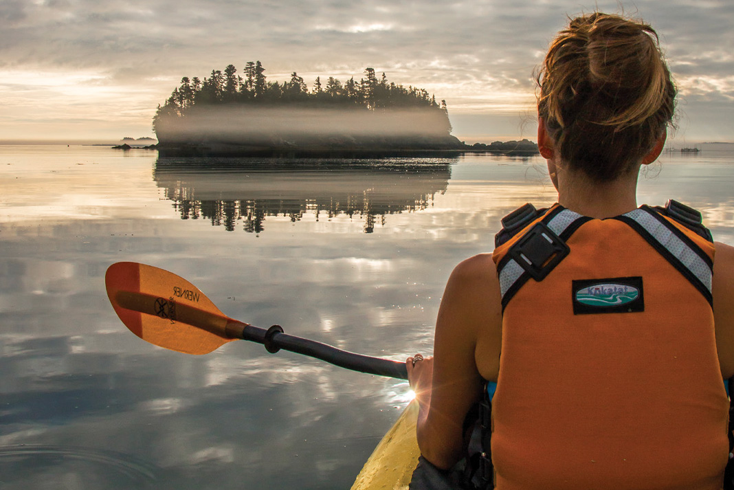
Ready for adventure? We’ve roamed the world’s oceans and lakes to compile this look at eight of our favorite island escapes, from lounging in the palm trees of the South Pacific to paddling with whales in the Bay of Fundy and gazing at grizzlies in Alaska. We’ve also included one escapade that’s so daring, it may never be repeated. —VM
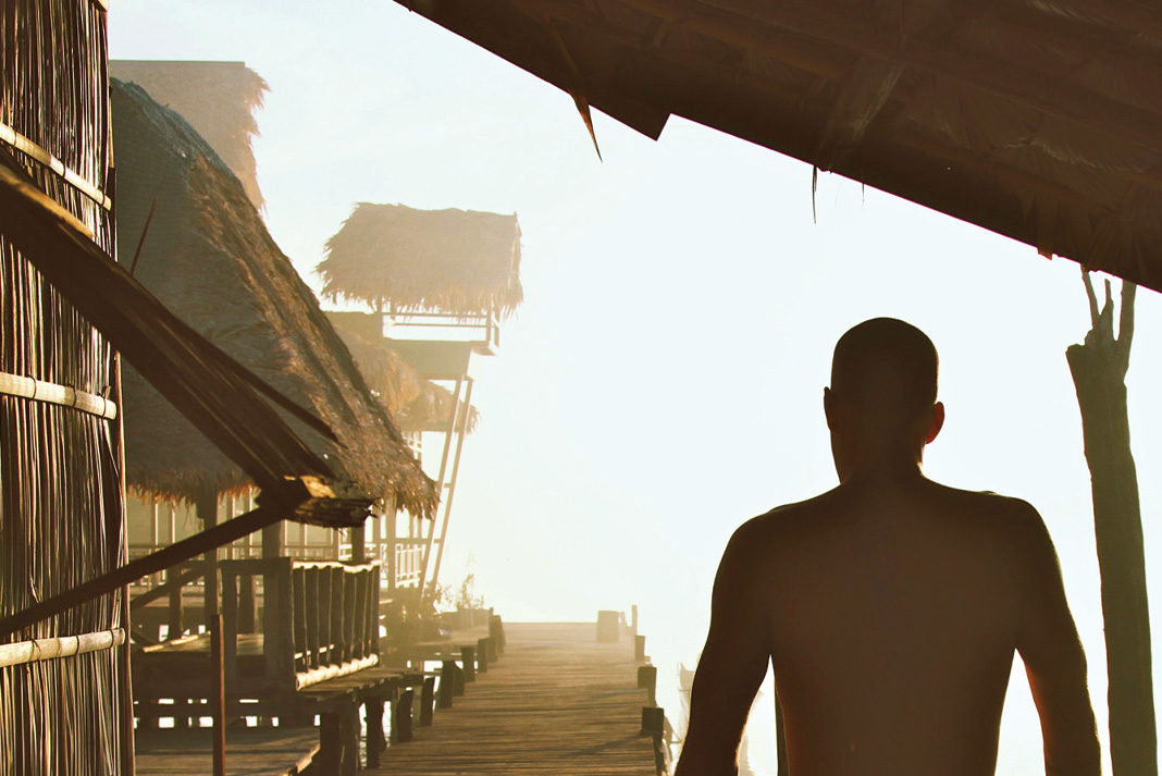
Raja Ampat
WEST PAPUA, INDONESIA
More than 1,500 small islands fringed by vibrant coral reefs and blue water mangroves make Raja Ampat a paradise for paddlers. Nestled in northeastern Indonesia’s West Papua province, the archipelago is home to the richest marine biodiversity found anywhere on earth. The warm waters teem with life, forming the livelihood for the local Papuan people. Over the last 20 years, the archipelago and its sprawling marine park have emerged as a leading example for sustainable ecotourism. The Raja Ampat Research & Conservation Centre (RARCC) supports the locals in developing community-based projects such as traditional homestays. Perched on stilts above the emerald waters, these palm-thatched guesthouses offer warm Papuan hospitality and authentic cuisine. Through the non-profit organization, Kayak4Conservation, locals have also learned the art of fiberglass boatbuilding, crafting a fleet of fully equipped sea kayaks. Crystalline waters reveal whales, manta rays, sea turtles, sharks and endless varieties of reef fish, all visible from the seat of a kayak gliding amidst the labyrinth of limestone karst islands.
The 140-kilometer circumnavigation of Gam Island encapsulates the diversity and essence of Raja Ampat. From leafy tunnels of mangrove forest and white sand beaches lined with coconut palms at the island’s south end, head north to explore Kaboie Bay’s soaring limestone stacks and hidden, paddle-in amphitheaters dripping with stalactites. Allow five to seven days, staying in the homestays found every 15 kilometers, or wilderness camping. Natural sources of freshwater are scarce, so bring collapsible containers for drinking water and plan to refill in your host communities. Monsoon season is from May to August; visit from October to December to enjoy sunny skies and the most stable weather. — Seth & Jenn Koebernick
IF YOU GO: Kayak4Conservation arranges homestays and offers kayak rentals and three- to 10-day trips with Papuan guides. The kayak fleet is still small (15 boats) so reserve in advance for rentals during peak season.
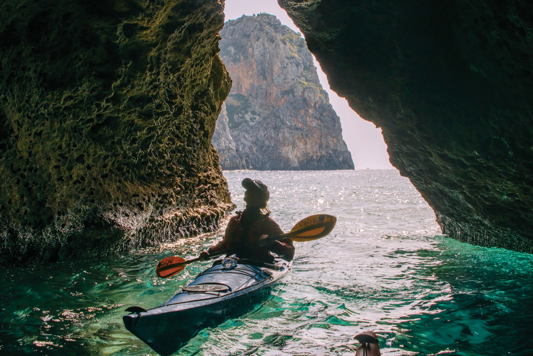
Crete
GREECE, MEDITERRANEAN SEA
On postcards beckoning visitors to Greece, the neon-blue waters of the eastern Mediterranean appear suspiciously enhanced. Not until sitting inside a kayak inches from the warm, alkaline water does it become apparent: that electric hue is not a trick of Photoshop. Greece’s largest island, Crete, is renowned for its varied and ethereal landscape, from the snow-capped White Mountains to surf-washed cobble beaches and scrublands peppered with pastures and orange groves. Crete’s role in Greek mythology is equally diverse—the island is celebrated as the birthplace of Zeus and dwelling place of the monstrous Minotaur.
Palaiochora, at the island’s western end, is a favorite launch point for overnight trips east to Hóra Sfakíon and beyond. The sun-bleached cliffs of Crete’s southern coastline dwarf paddlers, while herds of goats traverse the impossibly vertical faces. Rock gardens and sea caves abound between the pretty coastal villages of Sougia, Agia Roumeli and Loutro. Agia Roumeli is perched at the southern entrance of the famed Samariá Gorge National Park. Plan a layover day here to hike the 16-kilometer trail up this ruggedly scenic, 1,500-foot-deep defile. While summer brings tour groups, arriving in April almost guarantees solitude on the water. The weather can change rapidly on this exposed coast, turning a calm day into a tempest of rain and boiling seas. Have a backup plan to hike or be prepared to wait out the wind. Luckily, every taverna will welcome you with plenty of rakı—a traditional apéritif not for the faint of heart —Addie Asbridge
IF YOU GO: Ferrying back from Hóra Sfakíon saves time but there’s no set schedule— be prepared to hop aboard when the whistle blows. Enjoy Crete offers kayak rentals, day trips and four- or eight-day guided tours.
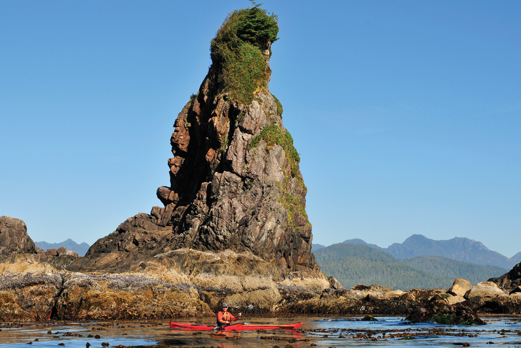
Bunsby Islands
CHECLESET BAY, BRITISH COLUMBIA
Untamed, isolated and exposed, few places better exemplify the wild nature of Vancouver Island’s rugged northwest coast than the Brooks Peninsula and the adjacent Bunsby Islands. Sheltered by the peninsula and the off-lying Barrier Islands, the Bunsbys are relatively protected from the mighty Pacific swell. Within their quiet passages, paddlers enjoy rich marine life, lovely wilderness campsites, unusual rock formations and spectacular sunsets. With the exception of Big Bunsby Island, which is a provincial park, all of the islands and their surrounding waters lie within the vast Checleset Bay Ecological Reserve. Along with important seabird nesting sites and an abundance of whales, the reserve is home to a thriving population of sea otters. Centuries of hunting lead to the extirpation of the sea otter from the B.C. coast in the 1830s, but the reintroduction of the luxuriantly furred marine mammals in 1969—and the creation of the reserve in 1981—has triggered a comeback. Today, rafts of the moon-faced critters feast on Checleset Bay’s smorgasbord of clams, abalone and sea urchins, and doze contentedly among the kelp beds, welcoming kayakers.
Kyuquot Sound is the starting point for most trips to the Bunsbys. The Kyuquot/Checleseht First Nation maintains launches at Artlish and Fair Harbour, from where it is a two-day paddle out the sound and up the coast to the islands. The final 11-kilometer stretch is an exposed crossing and for this reason it’s best to camp at the mouth of the sound and wait for a weather window to cross to the islands. Both the Mission Group, lying just north of the sound, and Rugged Point Provincial Park, at Kyuquot’s south entrance, offer wonderful opportunities for first (or last) night camping and exploring. Don’t miss the short footpath through lush old-growth Sitka forest to Rugged Point’s south beach—a clean, expansive crescent of fine sand printed with wolf, bear and cougar tracks. —Virginia Marshall
IF YOU GO: West Coast Expeditions offers multi-day trips to the Bunsby Islands from their idyllic basecamp on Spring (Tle:hoh) Island in the Mission Group.
Cuba
CARIBBEAN SEA
From cultural stereotypes like Cuban cigars and vintage American cars, to political iconoclasts like Che Guevara and Fidel Castro, the largest of the Caribbean islands is also one of its most eclectic, diverse and fascinating. Cuba’s natural history is just as remarkable. One hundred million years ago, the island rode the drifting continental plates, hitchhiking from the Pacific Ocean to the Caribbean. Today, more than half of Cuba’s plants and animals are found nowhere else on the planet. From leaping crocodiles, bat-eating boas and millions of bright orange crabs marching through the forest each year, to miniature frogs and the Caribbean’s largest flock of flamingos, Cuba surprises at every turn. Due to limited development, the island is also home to arguably the healthiest coral reef ecosystems in the Caribbean, if not the world. Ancient coral cliffs, pristine mangrove forests, white and black sand beaches, mountainous lakes and rivers yet to be explored by outsiders make Cuba a paradise for adventurous paddlers.
Cuba’s thawing relations with the U.S. will no doubt bring great change to this insular country, and the chance to be part of an exclusive club is reason enough to visit now. In 2014, Cuba Kayak Adventures (now Cuba Adventure Company) became the first commercial outfitter to be granted permission to paddle these heavily restricted waters. “Putting together an adventure kayak program in Cuba was a Herculean effort, but worth every minute,” says Cuba Kayak Adventures founder Jay Mothersill. Explore the mangrove lagoons of the Guamá Islands, tour the waterfalls and grottoes of the spectacular mountain lake of Hanabanilla, ride aquamarine swell and paddle with pink flamingoes on the south coast. —Peter Whaley
IF YOU GO: For now, it’s virtually impossible for individuals to legally access coastal waters with personal kayaks, and rental boats are restricted to within resort boundaries. Instead, during the dry season November through April, join an eight-day tour with Cuba Adventure Company.
Fundy Isles
BAY OF FUNDY, NEW BRUNSWICK
Wedged between the Canadian Maritime provinces of New Brunswick and Nova Scotia, the Bay of Fundy is notorious for its massive tides, rising and falling up to 50 feet every 12 hours. At the mouth of the Bay hides a relatively unexplored archipelago of islands, shrouded by the fog that so often blankets this area. The Fundy Isles are sparsely populated—colorful fishing villages, herring weirs and lobster traps dot their coastlines. As the tide ebbs and flows around the islands, rich nutrients are stirred from the ocean floor creating an ecosystem that plays host to a vibrant community of marine life, including at least eight species of whales. Bruce Smith, who has been paddling these waters for over 20 years with his company Seascape Kayak Tours, confirms this complex food web “supports what scientists have identified as one of the world’s biodiversity hotspots.”
The eastern shore of Deer Island provides the perfect jumping off point to explore the magic of the West Isles. Deer Island is only accessible by ferry from mainland New Brunswick or via Campobello Island if arriving from Maine. Spend a day paddling the rocky shoreline, then make the two-kilometer crossing to undeveloped Casco Bay Island and choose a beach to set up camp. Enjoy sweeping views of the iconic Head Harbour lighthouse and access to the Isles’ best paddling and wildlife viewing. Don’t let the tranquility fool you; the southern tip of Deer Island is home to Old Sow Whirlpool, the largest in the western hemisphere. To the north, a tricky web of tidal currents race between the islands. Proficiency with chart, tide tables and compass are crucial when navigating these chilly waters. — Harry Daley
IF YOU GO: August and September provide the best weather and wildlife viewing opportunities. Based on Deer Island, Seascape Kayak Tours offer sunset, half-day, day and multi-day tours in the West Isles.
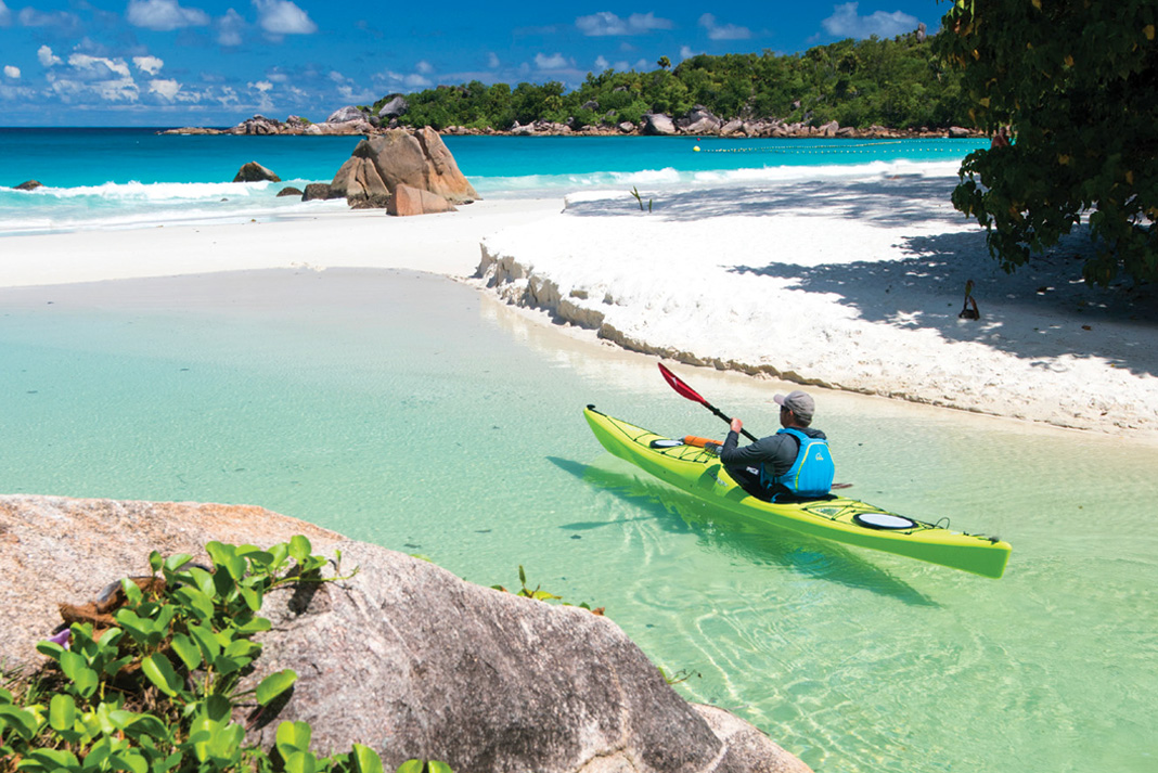
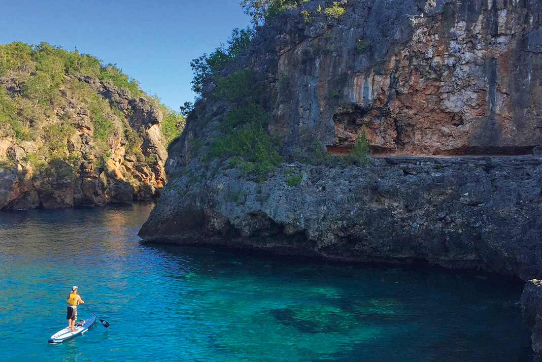
Seychelles
EAST AFRICA
Located 1,500 kilometers off the coast of East Africa in the Indian Ocean, midway between the Horn of Africa and Madagascar, the Seychelles are a tantalizing idyll of white sand beaches, ancient granite, lush rainforest, swaying palms and emerald waters. Paddlers exploring the central archipelago’s 32 Inner Islands are spoiled for choice. The spectrum ranges from the main island of Mahé— with 72,000 inhabitants, spectacular foggy forests and a national park around the highest mountain, Morne Seychellois (2,969 feet)—to the tiny atoll of St. Pierre. Just 100 feet across and crowned with palms, the real magic here occurs beyond the beach, where deep currents lure colorful fish of all shapes and sizes to the coral reef and sea turtles glide amid rapt snorkelers.
The islands’ splendor makes them a popular tourist destination, but kayaks offer a passport away from the crowds. Access isolated tropical beaches like Anse Badamier on the national park island of Curieuse, home to hundreds of giant Aldabra tortoises and known as the “very most beautiful beach in the world.” Explore beyond the world-famous beaches and striking granite boulders of La Digue, paddling into forgotten bays on the island’s far side where local families serve up papaya shakes and Creole curry. Many more islands are uninhabited—nearly 50 percent of the country’s total land area is designated nature reserve. While you can explore the Seychelles with your own kayaks, it’s hard to beat chartering a yacht with a guide and local skipper. These comfortable sailing vessels are the camper vans of the islands, serving as motherships for kayakers while hitting all the hard-to-reach highlights of the Inner Islands. —Stephan Glocker & Michael Neumann
IF YOU GO: There are no readily available sea kayak rentals in the Seychelles. Bring your own boats or spring for a multi-day sail-and-kayak tour with Silhouette Cruises.
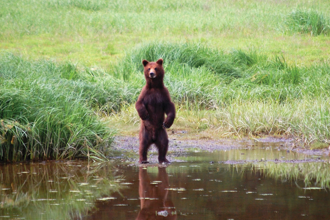
Kootznoowoo Wilderness
ADMIRALTY ISLAND, ALASKA
Admiralty Island is better described by its Tlingit name, Kootznoowoo, meaning Fortress of the Brown Bear. Located in Southeast Alaska’s Alexander Archipelago, the island’s old-growth temperate rainforest makes it the most ecologically intact large island in the Tongass National Forest, and it is believed to have the world’s densest population of brown bears—roughly one per square mile. Thanks to conservationists who battled timber companies, most of the mountainous island is now designated a National Monument. Ken Leghorn, a wilderness guide who has spent decades sharing Kootznoowoo with visitors, calls the island a “timeless place for undiminished wild salmon, bears and eagles, where solitude and adventure can still be found throughout the year.” Overshadowed by nearby Glacier Bay National Park, Kootznoowoo offers paddlers more solitude, wildness and critter viewing opportunities than the comparatively crowded park. Besides the coastal grizzlies, its bays are full of humpback and orca whales, Steller sea lions, sea otters and hundreds of breeding bald eagles.
The island’s most popular kayak trip begins in Juneau, Alaska’s small and isolated capital. A five-mile open water crossing of blustery Stephens Passage ushers paddlers into Kootznoowoo’s narrow Oliver Inlet, where a short portage leads over muskeg to Seymour Canal. From there, it’s just 15 miles south to the famous Pack Creek Brown Bear Viewing Area. During salmon spawning season July through August, all sizable streams and estuaries offer opportunities for seeing bruins, but many of the bears at Pack Creek are accustomed to visitors. Few kayakers venture beyond Pack Creek; if you do, expect a whole lot of solitude. For a truly existential experience, spend a couple weeks (or more) making a 250-mile circumnavigation of the island. Unpredictable weather, currents and bears make this a challenging trip for experienced wilderness travelers. Learn proper bear etiquette—how to store your food, where to camp (and where not to) and how you should behave if confronted by a bear—before venturing onto the island. — Bjorn Dihle
IF YOU GO: Visit from mid-May through mid-August for best weather and wildlife viewing. Above & Beyond Alaska offers day and multi-day kayak rentals and floatplane packages.
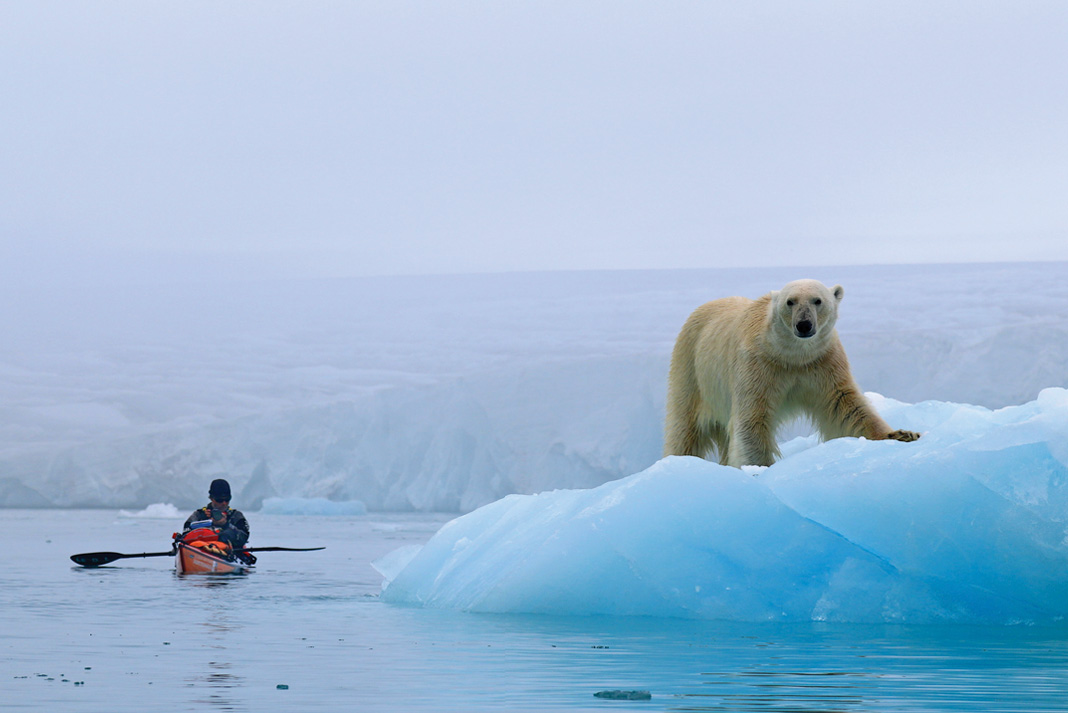
Svalbard Archipelago
ARCTIC NORWAY
Tears streamed down my face. Through the fog I watched the faint outline of my two companions moving further and further away from me with each passing hour. I battled with every stroke, struggling to stay awake, my mind exhausted and my hands numb with cold.
For centuries, explorers and dreamers have been drawn to the icy waters and barren landscapes of the Arctic. Inspired by romantic notions of the Land of the Midnight Sun, where polar bears roam across ice and tundra and glaciers plunge into the ocean, early adventurers journeyed on quests ever further above the Arctic Circle. Many of those bound for the North Pole departed Svalbard, a cluster of isolated islands anchored roughly midway between mainland Norway and the pole. Time passed, and although those pioneering days slowly faded into history, the magnetic attraction was not lost. It was deep inside of me.
So, on a foggy day in late June 2015, Jaime Sharp, Per Gustav (“PG”) Porsanger and I left on our own quest—to paddle more than 2,000 kilometers around the four main islands of Svalbard. The route around this desolate Arctic archipelago was, despite the passage of time, a circumnavigation that remained unclaimed.
Seven years earlier, two paddlers—Alon Ohad and Tim Starr—set off from the colorful settlement of Longyearbyen on the largest island, Spitsbergen, and paddled north, their kayaks loaded with what they hoped would be enough supplies to get them around the first-ever circumnavigation of the archipelago. Passing tumbling glaciers and windswept landscapes they worked their way towards the 80th parallel. On the coast of Nordaustlandet—the northernmost island and the crux of the circumnavigation, guarded by a 160-kilometer stretch of glacial cliffs and the highest numbers of Svalbard’s infamous polar bears—they were trapped in sea ice. After five hours of hauling their 200-pound kayaks across the shifting ice mass, a back injury forced the pair to call for an evacuation.
The second major attempt followed two years later. Two young Norwegians—Sebastian Plur Nilssen and Ludvig Fjeld—struggled north, battling the strong winds that funneled out of the mouths of the archipelago’s massive fiords. Two weeks in, they burned a pile of their food supplies to lighten the load and increase their speed. Then, after 24 days, their journey came to an abrupt end. While they were sleeping, a polar bear crawled under their trip wire, ripped through the tent and grabbed Sebastian’s head in its jaws. Ludvig shot the bear, likely saving his friend’s life. After a rescue helicopter delivered Sebastian to Longyearbyen for surgery, he spent three months in the hospital recovering from a punctured lung and extensive injuries to his chest and shoulder.
The incident cast a pall on the circumnavigation, and for the next five years the coastline remained silent. It was clear that in order for us to succeed, we needed a team of at least three. That way we could maintain a bear watch roster, with one of us staying awake and on guard at all times.
The crunching of my bow slicing through bands of brash ice awoke me from my thoughts. Somewhere beside us, the occasional booming of glaciers slowly faded into an eerie silence. It had been damp for days and I longed to escape the fog and paddle in the glistening sunshine again.
That evening, camped on a small island, I climbed a hill behind our tents. A few hundred meters away, a polar bear roamed over a ridge. It paused and looked at me for a moment before continuing away from our camp. For as far as I could see, the ocean was covered in sheets of broken sea ice with thin veins of water between.
As a team we were walking on equally unstable ice. Conflicts in personalities, paddling speed and goals created an uncomfortable tension that I struggled to shake. I had never expected that the competitive and controlling tendencies of someone else could affect my self-esteem so drastically.
On past journeys, paddling alone around New Zealand and Vancouver Island, I’d found inner contentment and a total sense of happiness. I enjoyed taking on challenges alone and the sense of satisfaction that came with succeeding was both empowering and humbling. I was left feeling a stronger, more confident person for it. But on this cold polar night I sat huddled by a small fire, tears rolling once more down my face. Never before had I felt so low in such a wild and beautiful place.
I hung onto the hope that when this journey was over, I would remember the splendor of camping on tundra alive with wildflowers, herds of reindeer roaming nearby, and the exhalations of beluga whales breaking the silence. Morale was low, but there was still beauty all around us. It was the one thing that kept me going. That, and the fact that there was no other option than to keep going.
Days were slowly becoming distinguishable from nights. The sun no longer moved in a halo above us. Instead, it swept the sky in a slow burning streak as it dipped towards the horizon. Soon, the land would be covered in a months-long blanket of darkness, the temperatures would plummet, and the sea would freeze into solid ice for the winter.
Our window was closing and we began paddling through the twilit nights in a bid to spend the few hours of dusk and darkness away from the bears. We were only a week’s paddle from Longyearbyen—just a few hundred kilometers away from closing the loop. Hour after hour, my paddle dipped in and out of the water. Rocky mountains and headlands slowly grew taller and then ever so slowly faded into the distance behind me. We crossed the mouths of wide fiords and bays backed by walls of calving ice. After nine weeks, it was as if nature wanted us to succeed. We had tiptoed lightly, and Svalbard had allowed us to pass. —Tara Mulvany
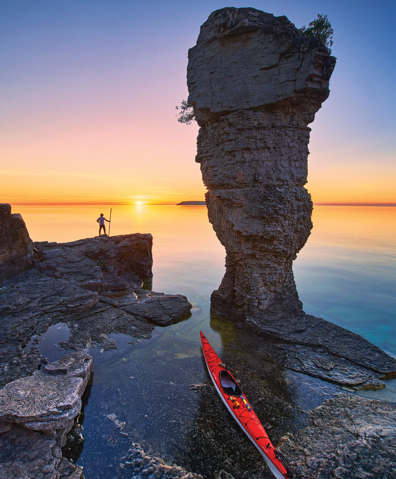
Fathom Five
LAKE HURON, ONTARIO
At the tip of Ontario’s Bruce Peninsula, where the white, fossilized cliffs of the Niagara Escarpment plunge into the cold, cobalt waters of Lake Huron, lies a constellation of limestone islands protected within Fathom Five National Marine Park. The park’s name is borrowed from Shakespeare’s The Tempest: “Full fathom five thy father lies; Of his bones are coral made; Those are pearls that were his eyes: Nothing of him that doth fade.” A fitting eponym given that the park, much of it underwater, was founded in 1972 to preserve the more than 20 shipwrecks that litter its shoals. A natural absence of silt and algae makes for spectacular water clarity, offering divers, snorkelers and kayakers the chance to view the ghostly remains of 19th-century schooners that once supplied the villages of Georgian Bay. Above the waves, the park’s seven main islands are home to two historic light stations, walking trails and—most famously—the Flowerpots, dolomite sea stacks eroded into fantastic shapes.
Flowerpot Island is a four-kilometer crossing from the Tobermory town docks in Little Tub Harbour. This is the only island with camping and the six sites fill quickly; overnight visitors should reserve when registration opens in early May. From the camping area, short trails lead to the two Flowerpots, a large cave and the immaculate red-and-white clapboard light station at Castle Bluff. Fathom Five’s many smaller islets beckon further exploration by kayak. Crossings are generally short but exposed, and paddlers should be prepared for near-frigid waters and boat traffic. — Virginia Marshall
IF YOU GO: May through September is the best time to visit. Kayak rentals and guided day trips are available through Thorncrest Outfitters in Tobermory.
 This article originally appeared in the Adventure Kayak Summer/Fall 2016 issue.
Subscribe to Paddling Magazine and get 25 years of digital magazine archives including our legacy titles: Rapid, Adventure Kayak and Canoeroots.


