Eighteenth- and 19th-century fur traders knew the vast network of waterways cascading over polished granite through endless black spruce on the Quebec side of James Bay as the Eastmain. Brigades of their freight canoes battled some of Canada’s mightiest rivers, pushing upstream to the hinterland trading outposts of Nemiskau, Neoskweskau, Mistassini and Nitchikun, and returning to the Bay laden with the continent’s lushest furs. But long before that, and still today, it’s known as Eeyou Itschee—“the People’s Land”—to the stalwart Cree who have made this wild country home since time immemorial.
Our monthlong trip into the heart of the Eastmain felt dystopian. I’d combed the Hudson Bay Company records, discovering how this region served as the focal point of Canada’s oldest enterprise until the 1960s. Just as the fur trade fizzled out, canoe trippers from Ontario’s legendary Camp Keewaydin reopened the old routes for recreational travel. I also knew about the plight of the Cree—how Quebec premier Robert Bourassa steamrolled Eeyou Itschee, ignorant of the Indigenous claims to the land in his intent to build the world’s largest complex of hydroelectric dams. Our route bridged the stark divide of then-and-now in a fractured wilderness mostly abandoned since Hydro-Quebec’s diversions, impoundments and powerhouses started reshaping the landscape in the 1970s.
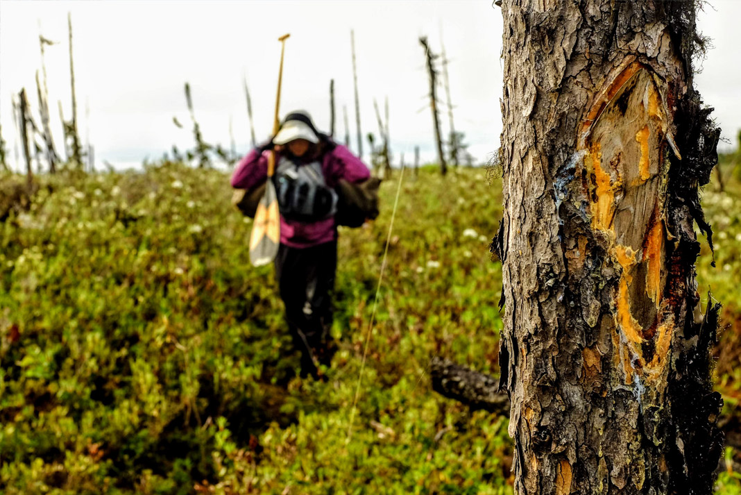
My wife, Kim, and I put-in on the Eastmain River north of Lac Mistassini, far upstream from the effects of the colossal dam. The first two weeks on the river included wonderful whitewater, stunning canyons, waterfalls and chutes. Just the two of us, we basked in a surprising sense of deep isolation. Where the riverbanks weren’t blackened by forest fires, the footpaths of the portages were tattooed on the mossy ground, with wizened spruce trees branded by ancient ax blazes. A few of our campsites were littered with rusty, decomposing tins—the remains of abandoned hunting camps. This was the Eastmain of old; it was hard to believe the steady current was drawing us into a drastically different world downstream.
The magic disappeared at the EM-1 Reservoir, a vast expanse of open-horizon floodplain, eroding sandbanks and drowned trees, buttressed by a dam the size of a city skyscraper—all in the middle of nowhere. The federal topographic maps we relied on for navigation have never been updated to reflect this massive hydrological change.
We paddled into a sterile, post-natural world. With the reservoir behind us, we faced the most recent phase of Bourassa’s legacy—an upstream leg on a diversion of the Rupert River, with high-volume rapids similar to those of the Ottawa and Colorado rivers.
This human-made waterway is barely 10 years old; the satellite imagery on Google Earth doesn’t even capture its flow. Ironically, our ancient topographical maps labeled this valley Ruisseau Caché—hidden creek—an apt description of what once was. That evening we wondered if we may have even been the first canoeists to ascend these waters. It was a heartbreaking revelation that made us marvel at the power of engineering and led us to consider the real impacts of green power, hidden in the hinterlands north of 50 and tethered to the south with humming 735-kilovolt transmission lines.
I love long canoe trips for the way they integrate physical and intellectual challenges. As much as the stimuli usually relates to the hardships and rewards of living small in a big land and sensing my place in the continuum of time, this trip imposed a different sort of reckoning.
Instead of the usual feelings of humility, here I was forced to acknowledge humanity’s immense power to reshape the land. It’s a notion that’s exceedingly hard to ponder from the seat of a canoe or sweating beneath the weight of a duffel on the portage trail.
Sault Ste. Marie, Ontario-based freelance writer Conor Mihell spends his summers paddling his wood-canvas canoe in northern Quebec .
Footpaths of ancient portages are tattooed on the mossy ground along the Eastmain River. | Photo: Conor Mihell




Good day Connor
I enjoyed your story.
When I was 18years old, I took my first summer job with Noranda mines,
They flew me to a town called Chibougamua, in Northern Quebec
I went with 2 other men, one was a Native Prospector that taught me everything in the Bush how to live and survive, another was a young U.of T, geology student
We too, went out canoeing along the furtrader routes. Noticing those same old rusty tin cans, along with a metal tag anchored , stating there was an old fur trading post Hudson Bay
Memories !!!
Thanks for your story
Robert
Hi! Great story. Do you have a map of your route? I am looking to a plan a route of the Eastmain myself and would really appreciate some information.