It’s a brilliant November morning in the heart of the Grand Canyon, and the ribbon of cold, clear sky framed by mile-high walls is growing bluer by the minute. A gentle breeze moves upstream along the Colorado River, rustling through camp. The temptation to kick back and enjoy the canyon’s finest hour is strong. But today we have a different agenda, one that takes us deep underground into a mysterious aquifer system to photograph and record data from what is among the least understood and last explored environments in the Grand Canyon.
Packrafting beneath the Grand Canyon
As the first beams of direct sunlight radiate into the river corridor, illuminating the exact spot on our camp table where a pot of hot coffee would normally be brewing, we’re already marching away from the comforts of river life toward a literal blank spot on the map.
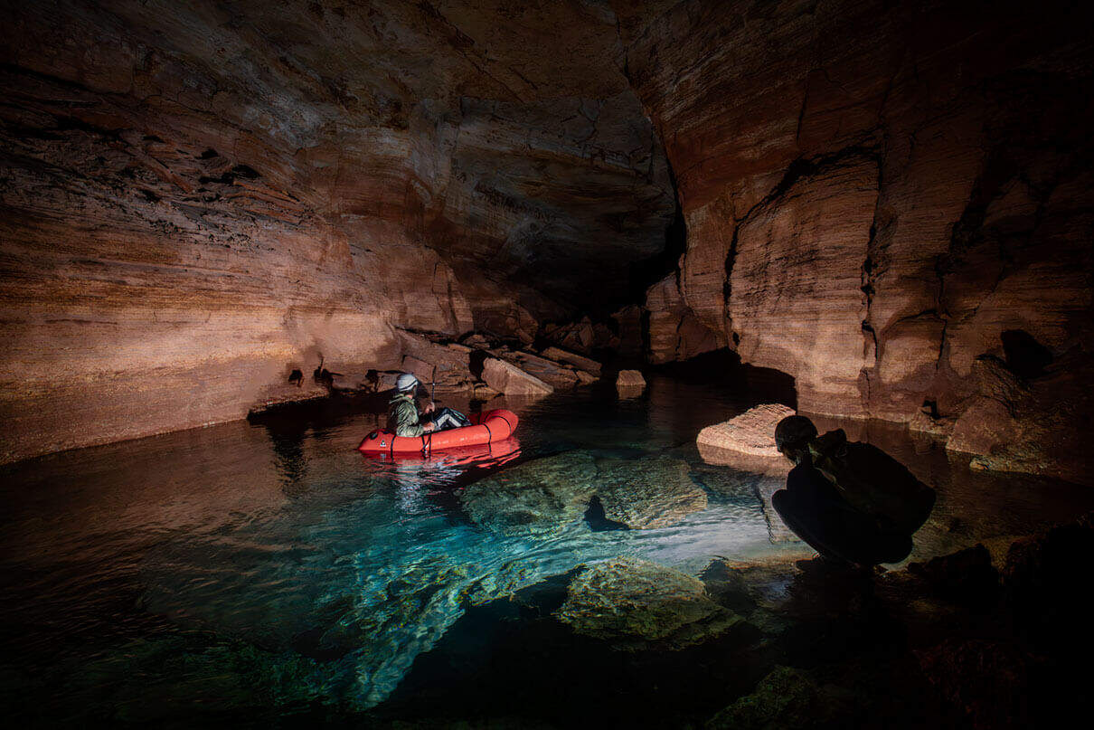
Traversing into an enormous limestone enclosure at the head of a perched valley, we locate an inconspicuous natural opening that leads underground. One by one, we leave our familiar surroundings behind and enter a hidden and puzzling realm that exists in total darkness. We set the beams of our headlamps to high and follow a meandering passage that leads us straight to the water table—a location easily identified by the presence of a river flowing through a majestic subterranean canyon.
This waterway, along with the voluminous chambers it courses through, is only part of a vast and complex karst aquifer system with hundreds of groundwater springs interconnected throughout the Grand Canyon. Known as the Redwall-Muav aquifer, it is arguably the most important source of freshwater in the Grand Canyon.
Once the ultralight packraft I unfurl from my backpack is inflated, I paddle across the underground river to a cluster of highly sensitive instruments logging data from within the system—flow rate, depth, volume, mineral content, temperature, relative humidity, barometric pressure and more. Cut off from GPS and the internet, the array must be checked manually, as the only way to retrieve the information is in person.
Of the hundreds of springs connected to this system, roughly two dozen are actively monitored by researchers, providing critical data that inform water management strategies amid ongoing drought and a changing climate. In a region where every drop counts, these remote monitoring efforts play a vital role in protecting fragile groundwater resources and ensuring long-term sustainability of both ecosystems in the Grand Canyon and human communities downstream.

With data from the loggers collected and carefully stowed, we follow the river deeper underground, using our raft to protect the delicate camera equipment for documenting the inside of this cave. At the far end of a hall the size of New York’s Grand Central Station, the river disappears beneath a mountain of boulders that block the passage entirely—the result of a collapsed ceiling. It’s clear that the cave and the river continue on the other side of the breakdown, but finding a way through—and into the great unknown—will be a whole expedition of its own.
Stephen Eginoire is a journalist and photographer rooted in southwestern Colorado. See more of his images from the vast, hidden cave systems beneath the Grand Canyon at stepheneginoire.com.
 This article was published in Issue 74 of Paddling Magazine.
 Packrafts have a way of showing up where you’d least expect—like ferrying researchers across underground rivers for climate-critical aquifer data. For safety, data collectors wear neoprene wetsuits and belt-pack PFDs. |
Feature photo: Stephen Eginoire


I am fairly certain that the word “the” does not belong in front of Grand Canyon. Like Glenn Canyon or Bryce Canyon the word “the” is not part of the name.