No hike is too far to paddle some sweet whitewater. During summer 2020, Sarah McNair-Landry and I set out to cross the Meta Incognita Peninsula on southern Baffin Island. Our 40-kilometer hiking route was prime for first descents, connecting four unrun rivers in the Canadian Arctic.
Arctic paddlers find first descents in their own backyard
When traveling in the Arctic, it’s important to be completely self-sufficient, prepared for bad weather and expect delays. We started the trip with 20 days of food and fuel, which meant our kayaks were loaded with 110 pounds of meals and gear—more than I had ever taken on a kayak-hike trip before. We also carried a 12-gauge shotgun, bear alarm fence and a solar panel, which accounted for some of the brutal weight. Baffin Island is home to polar bears, and we needed to be prepared.
The Meta Incognita Peninsula separates Sarah’s hometown of Iqaluit, the capital of Nunavut, and the small community of Kimmirut. The peninsula’s plateau rises about 2,000 feet high and features hundreds of freshwater lakes feeding the many rivers descending through the south coast. On flights into Iqaluit, I would occasionally get a glimpse of waterfalls on the peninsula and always wondered what those rivers would be like to paddle. Since travel was erratic in 2020 with pandemic restrictions, we decided it was time to find out what was in our backyard.
Hiking toward a highway of whitewater
From the ocean, we spent two days hiking uphill. At first, our loads were too heavy to carry all at once, so we broke them into two. The only downside to dividing the gear in half is we had to walk three times the distance to cover the same route.
After a lot of hard work and sweat, we reached a series of lakes leading us to the first river. It felt good to be paddling downstream even though we didn’t expect many rapids at first, based on our scouting via satellite images. This low-volume river was our highway to access three more rivers that showed even more whitewater potential, based on what we could see on satellite images.
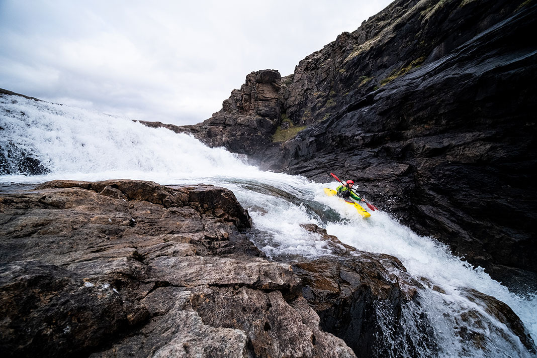
To our surprise, this first river picked up speed and pinched through a small gorge with class V drops. The first two falls led into a large turbulent pool and another waterfall just downstream with a nasty undercut and no way to set safety properly.
Fortunately, a microeddy on the right gave me the option to run the upper section. I managed to get out, portage around the dangerous rapid, and seal launch back in. Sarah set safety. With her throw line bag in one hand, she snapped the photograph that accompanies this article before portaging around the canyon.
Not long after this surprise canyon, we hauled our kayaks onto our shoulders and hiked seven kilometers up and over into the next river drainage.
Arctic rivers offer up the unknown
Before departing on this trip, the only information we could get on these remote arctic rivers was from low-resolution satellite images and rudimentary topographical maps. We were rolling into the unknown, which is what I love the most about these exploratory expeditions.
In June 2022, Erik Boomer and Sarah McNair-Landry set out on another 70-day multisport adventure, their third Baffin Island summer vacation.
This article was first published in the Early Summer 2022 issue of Paddling Magazine. Subscribe to Paddling Magazine’s print and digital editions, or browse the archives.
Boomer notching an Arctic first descent on Baffin Island. | Feature photo: Sarah McNair-Landry


