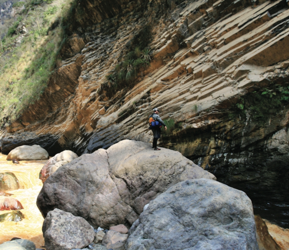
Disappearing into a deep canyon abyss just downstream of Huanuco in northern Peru, El Rio Huallaga carves its course around the base of a massive Andean peak, and doesn’t rejoin a road until it drifts into the steamy jungle town of Tingo Maria nearly a hundred kilometres later. The Department of Huanuco considers this River Styx unsafe for travel and the U.S. State Department forbids its employees from visiting it. The jungle surrounding the Huallaga’s lower reaches bubbles with malaria and besides Kurt Casey’s original attempt of the Huallaga in 1999, few Westerners have ever peered into the canyon’s depths.
On July 10, 2007, Andrew Oberhardt, Todd Gillman, Shane Robinson and I boarded American Airlines Flight 827 bound for Lima, Peru. Our mission: attempt the un-run stretch of the Huallaga that Casey’s team was unable to complete. Our team, The Range Life, was selected by the Vacation to Hell steering committee and awarded $12,000 to explore and document this last major un-run tributary of the Amazon.
It’s easy to see why the Immersion Research Vacation To Hell board members decided this would be the perfect holiday.
The Huallaga is a logistical nightmare. Situated in northern Peru’s Department of Huanuco, it is far better known for its history with the Maoist rebel group The Shining Path, and for coca production, than as a kayaking destination.
Research leading up to the trip had yielded scant results beyond ’70s topographic data, Kurt Casey’s failed trip report, and plenty of horror stories about the cocaleros and the Shining Path.
After arriving in Lima we made our way towards Huanuco, where we connected with Peruvian whitewater guru Piero Vellutino, who proved invaluable. Few locals knew anything about the deep canyon’s lower reaches. Pilots in Huanuco and Tingo flatly refused our requests for an aerial reconnaissance mission. Hiking the canyon with the help of a pack string was said to be impossible.
After 10 days in Huanuco, the sum total of our preparations was trumped by a couple hours of Piero’s research. We learned that there was in fact a trail some 1,200 metres high on the river-right canyon wall that offered possible egress in the event of a bail-out. Still, we were left with little other option than to just head in.
Late in the afternoon on July 22 we piled four Jefes and Piero’s H3 into the back of a worn Toyota pickup and headed off to Puente El Rancho to put in on the Huallaga.
It was just our second day on the river when we reached the towering gorge that forced the Casey expedition into a multiday evacuation. By sending one team high to scout the lower portion of the gorge and another at river level on the right to scout the entrance, we managed to put together a safe line through a series of blind ledges, dropping ever deeper into the canyon. Only strong teamwork made it possible for us to make good time through innumerable unseen and gorged-out rapids.
On the afternoon of our third day, one filled with endless boat-scoutable class IV–V rapids, the character of the river began to change. The canyon walls closed in dramatically and we had considerably more volume than when we started. The dense vegetation hanging from the gorge walls meant we had made the descent into a new climatic zone, la selva.
We were deep in the section of the river we’d referred to in our planning as the Great Bend. It was here that the river takes a 90- degree bend to the left and the canyon walls soar to more than 2,000 metres. That night in camp Piero, Andrew, Shane, Todd and I pored over the 30-year-old topos trying to count the gradient lines in the next 30 to 40 kilometres. The 1:100,000 maps were as good as we could get but lacked the detail we needed to be certain of what lay ahead. They were littered with wide swaths of white space and the words “datos insufcientes.” Insufficient data is the last thing you want to see on a topo when you are trying to reason your way through a potentially unreasonable river.
We woke up the next morning to a muddy river. The overall mood had shifted from stoked to somber. Knowing that we were about to paddle into a cavernous dirty gorge that dropped several hundred feet per mile, we pushed on cautiously.
The river disappeared into another, even more committing gorge
The Huallaga cascaded down a very marginal, sieve-laden rapid before disappearing under a huge chock stone 10 or 13 metres high, and then into what appeared to be an unscoutable, unportagable canyon. Scouting river left was impossible due to the gorge wall that shot up 1,500 metres from river level.
Todd and I volunteered to scale the steep and densely vegetated right wall to gain a vantage of what lay downstream. Beating our way through vines that would silently wrap around our ankles and any exposed gear, pulling us to the ground in an instant, we finally reached a high point on river right after about an hour of jungle bushwhacking. Unable to see into the canyon, we dropped down toward the gorge rim and belayed Todd over the edge to inspect.
From what he could see, the rapid under and just downstream of the chock stone might go. The crux being the exit rapid which had a super boily entrance with compression wave features, then a fast, narrow tongue down the middle, over a steep vertical ledge with massive holes and pockets on both walls. We felt good about it, but the problem was downstream.
Even if we were able to deal with this canyon, the river disappeared into another, even more committing gorge. From our perch, we could see that there was an eddy at the lip of the drop leading into the gorge, but from there, if we didn’t like what we saw, there were no options for egress right or left. We headed back to the rest of the team to give the grim details.
Piero, Shane, and Andrew sat on the rocks deep in discussion with the topos, GPS, and SAT phone littered about. Our plan B of accessing the old Inca trail 1,200 metres up on river right would disappear if we pushed on. We still had 60 kilometres left of the steepest and most committing section of river, and we had only travelled one kilometre in more than three hours.
Our river senses were telling us to get out. Slowly we came to the conclusion that we had to, at a bare minimum, hike around what lay below us. Shane described it as “this feeling of relief where you decide to go with your instincts of survival and judgment, versus your ego to want to complete something big.” None of us wanted to leave the river.
Piero and Todd bushwhacked ahead with the machete to scout a possible evacuation route while Shane, Andrew, and I began roping boats. It was slow.
In two hours we moved the boats only about 400 feet up the relentless terrain. Then Piero returned. “I hope you guys have insurance, ‘cause we are going to need a helicopter to get out of here.” As he was dialing numbers on our satellite phone leaving messages with his family and any other helpful connections he had, the rest of us hacked out a base camp on a thin, rocky jungle ledge above the churning, victorious Huallaga.
Fighting fierce ants we camped and waited. Our gear was soiled in mud, we were battered and demoralized. As we awaited rescue or finding our own escape route, the reality slowly set in; we were not on an ordinary summer vacation. We were at the gates of Hell, temptation trying to lure us in and divine judgment telling us not to look back.
This article first appeared in the Early Summer 2008 issue of Rapid Magazine.


