
As we inch our canoe past the safety of an upstream sandbar and into an onslaught of waves, I panic. “I can’t do this! Let’s turn around!” I shout to Daniel in the bow. He allows me to steer the canoe back to the safety of shore, moments before it would have been too late.
Usually, Daniel and I paddle within about 50 meters of shore when it’s windy, but now we are trapped on an island with least one kilometer of wind-thrashed waves separating us from the shore we need to get to. Daniel wants to go for it, but I’m scared. I shed a few tears of self-pity, then we set up the tent and wait.
Around here, the Mackenzie River calls the shots.
It’s Canada’s longest river and our largest watershed, covering more than one and a half times the land area of Ontario. The year 2014 marked marks the 225-year anniversary since Alexander Mackenzie of the Northwest Company traveled the river with aboriginal guides. Long before his time, this river was known as the Dehcho, or Great River. It connects the Dehcho, Sahtu and Gwich’in First Nation regions (who are, collectively, the Dene people) as well as the Inuvialuit Settlement Region near the Mackenzie Delta.
Visitors, who come from all over the world to paddle the Mackenzie, think of it a great wilderness river, but for the Dene, it’s simply their backyard. It is here they have always hunted, fished and traveled.
That backyard could be changing. Oil and gas interests are picking up in the central valley area, and an extension of the Mackenzie Valley all-season road may soon be penetrating deeper into its boreal forest and muskeg, providing easier access to the region for local First Nations and developers alike. The Mackenzie River may always be big and powerful, but it might not always be the place it is today.
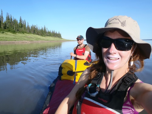
I’m canoeing with Daniel Campbell, a friend-of-a-friend who hails from this territory’s capital. We put in a few days upstream of Wrigley, N.W.T. and our end destination is Inuvik, more than 1,000 kilometers downstream.
On our second day, we get a visit from Jonas and Tony, two Dene men from Willowlake River. Daniel and I had just finished unloading our barrels and bags onto a beautiful sand bar next to a creek when they cut the engine of their jet boat and drift to shore. They are going hunting for a night or two, Jonas explains, but I notice their boat is mostly empty apart from a couple of guns and some snacks. They plan to curl up on the rocks under the stars—no tent, no sleeping pad—says Jonas, as he eyes our pile of bags and barrels.
Tony doesn’t speak English but Jonas tells us Tony’s aunt is buried across the creek, where we noticed a small fenced area. Tony sits in the boat smiling, his blue eyes twinkling when I offer them chocolate. Then they’re off again, into the dusky horizon of a sun reluctant to set.
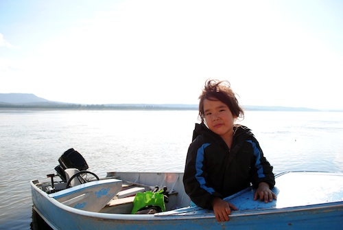
It’s hot when we arrive in Wrigley and hit the empty streets in search of a place to fill our water jugs. Today is Canada Day and everything is closed, but we have the good fortune of meeting the water truck driver on his driveway. He fills up our jug straight from his truck while his girlfriend brings us a bag of ice from inside the house Katy points at houses down the street, showing us where her parents, grandparents and cousins live, all within shouting distance.
Wrigley is the northern terminus of the Mackenzie Highway, a gravel road completed in 1994 that links the tiny community of 150 people to the Alberta border. It’s a quiet place, but Wrigley’s relative isolation may change when it’s no longer at the end of the road. The 333-kilometer highway extension north to Norman Wells is in the planning stages, with the overall goal being to extend it all the way to the Dempster Highway near Inuvik.
The highway will be built over the existing winter road, which parallels the Mackenzie River in several places. As we pass the fish-filled tributaries downriver, I imagine what it would be like to pass a family picnicking on the gravel bar or a bunch of anglers in their waders. Or worse, the plumes of dust that are sure to follow every driver on these dry gravel roads.
The Mackenzie River is already far from untouched: there are signs of humans everywhere. We don’t see jet boats whizzing by, barges transporting supplies up and down the valley and rustic cabins dotting the shore between the six communities we visit.
I consider the Mackenzie River a low-risk, high-consequence river. It’s so slow and sluggish, it would be almost hard to capsize a canoe during calm weather. But if did happen, it would be extremely dangerous. The river is consistently more than a kilometer wide and it’s frigid—so cold I couldn’t bring myself to take a dip on even the hottest days.
Daniel and I are almost sun-blind when we land in Tulita, a community of 500 people located on a bank above the mouth of the crystal clear Great Bear River.
Our next community is the oil town of Norman Wells. By now we are able to cover 60 to 80 kilometers a day, so the 78-kilometer paddle between Norman Wells and Tulita would be a piece of cake to cover in two days, without the nasty head wind that makes us work for each stroke. Strong winds are normal around “the Wells,” where the river widens to more than five kilometers across.
I knew about the Wells before arriving was that Imperial oil had been drilling here since the 1920s, so I wasn’t expecting much in terms of scenery. It was a pleasant surprise to find that the community of 700 or so people has a beautiful mountain backdrop, even though the closest slope has been chewed away by a giant quarry. This boom and bust town is a halfway point for many paddlers, because of its location and amenities. Unlike Wrigley and Tulita, Norman Wells has a couple of restaurants and watering holes, as well as the last liquor store for 700 kiometers.
The weather is bad on departure day, so Daniel and I drag breakfast and lunch out until 3 p.m., when the water has calmed significantly. Soon after we get on the river the wind dies and the water turns to glass. It’s a beyond perfect evening.
“Is that smoke?”
It’s close to 11 p.m. and time to look for a place to camp. As we get closer to shore, we notice a few trees burning. It is smoke! We decide we should camp on the large island on our left to avoid the smouldering fire but we see a black bear swim across the channel and onto that same island. Five-hundred meters downriver, a dozen or so tents dot the shore. It’s a group of voyageur canoeists, whom we met the previous day. They are usually on the water by 6 a.m., they told us, hence the reason they are already sleeping. We watch the bear wander into the forest and, satisfied it isn’t going to bother the group, keep going. Daniel and I find a spot downriver that is smoky but bear-free.
The ramparts is an area just upstream of Fort Good Hope where the Mackenzie River narrows exponentially as it flows between 90-metre high limestone cliffs. There are some rapids at the entrance to the narrows, but following the advice of our guidebook, we stayed right and avoided them altogether.
Not so much for Chris Miele, a solo paddler who arrived in Inuvik a few days after Daniel and me. The 25-year-old was moving from Vancouver, B.C., to Iceland to start a master’s degree, and brought everything he needed for school down the river, packed in suitcases. Following the advice of a hunter, Chris went left through the Ramparts, which our guidebook says only to do at high water. The river was extremely low and Chris went over a three-foot ledge that filled his canoe with water. Miraculously, his boat didn’t tip and he was eventually expelled from the swirling water and able to slowly make his way to shore. Perhaps more amazingly, he didn’t lose anything in the process.
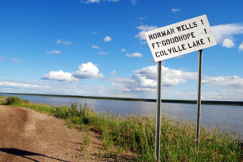
High above the river in Fort Good Hope a large cross commemorates a small church built over 20 years starting in 1865. The inside is painted with outrageously bright colors made from fish oil and adorned with two paintings by the prolific northern artist Bern Will Brown, a former priest who lived in nearby Colville Lake until his death earlier this year.
Two paddlers I met in Inuvik told me they got engaged in this church. Considering that a canoe is often jokingly referred to as a divorce boat, I’m guessing that any relationship that survives a multi-week canoe trip is likely to last.
While touring the church, Daniel and I meet the ever-hospitable Sisters Joan and Pauline, who feed us one of the best meals of trip and cordially beat us at their favorite card game.
It’s during the seven-day stretch to Tsiigehtchic that Daniel and I get stuck on an island in a windstorm. After 24-hours, there’s a break in the weather.
“Time to go!” Daniel says excitedly. Without another word, we break camp and throw our gear in the canoe, allowing ourselves to cheer as we shoved off. There’s nothing like a day spent on a wind-scoured sand bar to make one go a little stir-crazy.
The next few days are rainy and windy, so it’s a welcome sight when we round a bend and see a white steeple illuminated by a ray of sun poking through the clouds in Tsiigehtchic. After visiting this friendly Gwich’in community of less than 200 people, we slog through the east channel of the Mackenzie Delta to arrive in Inuvik, our final destination. We can hear the town of about 3,500 people before we can see it: airplanes zip in and out of the airport, high-end jet boats blow past us and the deafening drone of the diesel generator reverberates upriver.
The Canadian Government planned and built Inuvik from scratch in the ’50s and although it’s small in population by southern standards, it has lots of things we haven’t seen in a while: a recreation center, large hotels and a full-sized grocery store. As we walk down the street past locals and other tourists, some speaking German and French, no one remarks on our arrival or waves from their passing truck. No one offers us a ride from the dock up to the campground either. For the first time in weeks, I am just another person in a sea of strangers. Our canoe trip on the Dehcho has come to an end.
—Karen McColl has been freelance writing since 2009 and has written for the CBC, the Globe and Mail, the Toronto Star, Outpost magazine, Up Here and Up Here Business magazines—
This article first appeared in the April issue of Paddling Magazine.


