As we watched the de Havilland Twin Otter fly off, circling over the still frozen Lady Franklin Bay, realization set in. For the next five weeks, we would be some of the most isolated people on earth. It was July 2 and we were at Fort Conger on Ellesmere Island, 500 nautical miles from the North Pole. We were embarking on a kayaking expedition through Nares Strait, the channel between Canada and Greenland.
We expected to cover roughly 500 kilometers. Our team of five included experienced polar explorers and a polar oceanographer. With us were 1,096 pounds of food and equipment, packed into our ultra-tough Prijon tandem kayaks.
Our goal was to get footage for our documentary, Enduring Ice, a film to draw attention to the darkening Arctic.
In the past 40 years, Arctic sea ice volume has declined by 72 percent. Most polar scientists now predict the Arctic Ocean will soon be ice-free in summertime. With that change, the Arctic Ocean is no longer the solar reflector for the planet like it once was. Our concept for the film was to use the excitement of an extraordinary adventure as a way to raise awareness about the essential role the Arctic’s sea ice plays in keeping our planet cool.
Based on past experiences in Nares Strait, our team imagined ice conditions might be different from previous expeditions, but still recognizable. They weren’t.
What we encountered was something new—a polar slurpee. A mess of unconsolidated ice that made travel by foot or paddle nearly impossible. Gone were the large solid ice floes. The conditions were especially surprising to the polar oceanographer on the expedition, who was accompanying us to add to his research on sea ice floe size distribution.
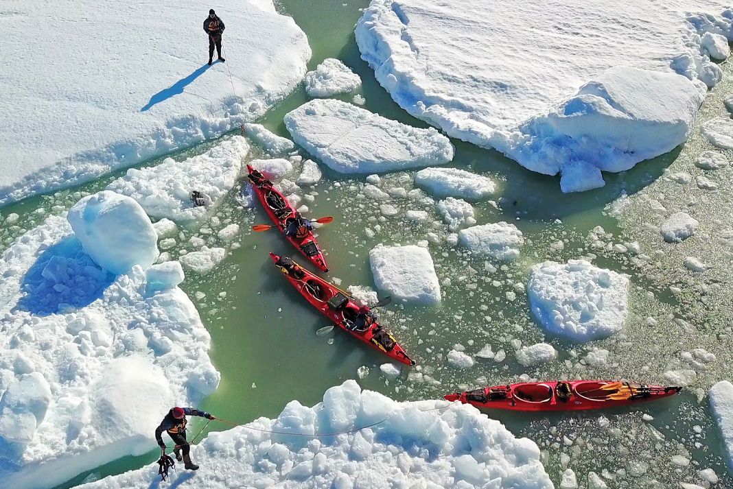
With ice conditions so challenging, we were mostly forced to follow the icefoot, that narrow band of sea ice frozen to the shore. However, because Nares Strait had not frozen across last winter, the icefoot was a mess. Giant blocks of ice tossed up during winter storms were stuck in place, and often impassable. We were completely beset by the deteriorating ice conditions we had come to document.
This image extracted from drone footage is of us navigating our kayak around one of these sections of almost impassable shore. It took 33 days to travel just 100 kilometers. Carl Ritter Bay, the closest landing strip, became our absolute goal.
Learn more about the Enduring Ice project and get updates on the documentary at www.enduringice.com.
 This article first appeared in the 2015 Paddling Buyer’s Guide. Subscribe to Paddling Magazine and get 25 years of digital magazine archives including our legacy titles: Rapid, Adventure Kayak and Canoeroots.


