
“The Stikine is huge, man. And fast,” exclaimed a canoe guide I know when I told him our plans to spend 10 days paddling 240 kilometers of the Lower Stikine River.
“The river just rips by, all those huge boilers and whirlpools. My advice: don’t paddle, or you’ll get to the end too soon.”
With this bizarre warning, we piled our gear—paddles included—into the truck and headed north.
The fastest navigable free-flowing river
The Stikine rises on the Spatsizi Plateau in northwestern B.C. before squirting violently through the unrunnable (for mere mortals, at least) 100-kilometer Grand Canyon of the Stikine.
From the bottom of the canyon at Telegraph Creek, British Columbia, to its communion with the Pacific at Wrangell, Alaska, the river drops nearly 1.3 meters per kilometer, a grade that makes it the fastest navigable free-flowing river in North America.
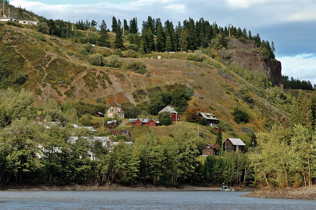
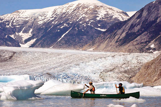
Even at our put-in at Telegraph Creek the size and strength of the Stikine stuns us—a 200-meter-wide channel of silt-laden water churns by at more than 20 kilometers per hour.
The Stikine’s cargo of salt
In 1879, legendary naturalist John Muir visited the Lower Stikine, calling it, “a Yosemite 100 miles long” whose “views change with bewildering rapidity.”
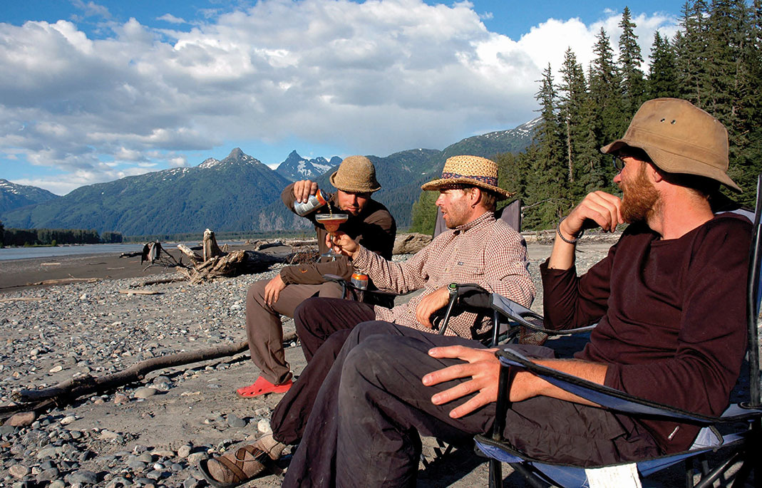
As we leave the drier pine forests of the interior behind and enter into the granite and glaciers of the Coast Mountains, we understand this to be a great compliment to Yosemite. Here the river becomes a boiling, coffee-with-cream-coloured waterway several hundred meters wide. We heed my friend’s advice and stow our paddles, feet dangling over the gunwales in the icy water.
Our canoes spin a lazy dance, showcasing a 360-degree panorama of peaks. The ABS bottom of the canoe hisses through the Stikine’s cargo of silt, and the cool air hints at the scent of pulverized granite in icy water. Bewildering indeed.
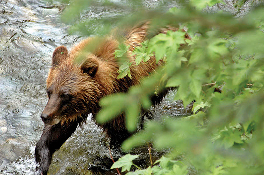
The wildness of this valley is etched on every sand and gravel bank we visit. Wolves, grizzly, black bear and moose have all scribbled their stories here. In Little Canyon—a notorious challenge both to modern canoeists and the sternwheelers that ferried 19th-century optimists inland to the Cassiar and Klondike gold rushes—we spot what looks like a bear swimming the confused waters of the 100-meter-deep rock cleft. Instead we realize that in this boiling, whirlpool-filled canyon, 170 kilometers from the sea, we are seeing our first seal.
An artery of trade and travel
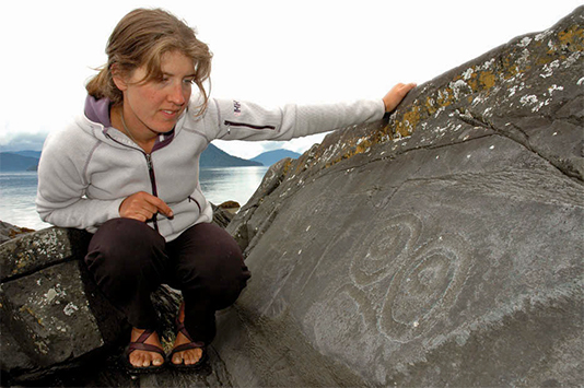
Like its scenery, the Stikine has a rich and storied past. An artery of trade and travel for millennia, local legend tells of a vast ice wall that once blocked the valley, under which the entire Stikine flowed through a gaping ice tunnel. To test whether their canoes could safely pass, traveling groups of the indigenous Tahltan would send an old woman through in a canoe. If she emerged unscathed, they knew the tunnel would offer safe passage downstream to trade with, or raid, the Tlingit villages on the coast.
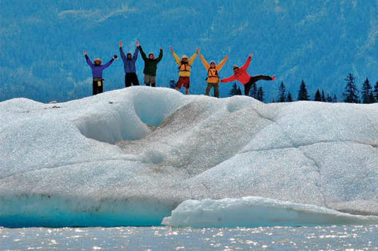
Today a remnant of this ice wall lies in a pool of its own meltblood—a large iceberg-choked lake separated from the river by a thin, treed moraine. Resisting the forward push of the river, we portage to this hidden lake and pass a day of contrasts playing chess and reading in the warm white-sand beside grounded icebergs. Ten-thousand-year-old ice commands us to break out our supposedly well-aged scotch, and we toast the Tahltan, the gold rushers and the spirit of adventure that brought us here.
[ Paddling Trip Guide: View all paddling trips in British Columbia ]
The First Nations presence on the Stikine is strong. Fading pictograms dot the shore, while sandy eddies bristle with well-tended salmon nets hung from long pine poles. Five salmon species return each year to the Stikine and have been a source of conflict for decades. Alaskan, Canadian and First Nations fishers have all angled for the grizzly’s share of the catch. Although the so-called Salmon Wars ended with a 1999 treaty, it is an uneasy truce and tensions are still palpable on both sides of the border, each country blaming the other for declining salmon stocks.
The Stikine salmon squabble was nearly rendered moot in the late 1970s when B.C. Hydro unveiled a plan to build five immense dams along the Grand Canyon of the Stikine and the Stikine’s main tributary, the Iskut River. The hubris required to build sufficient dams along this river is hard to conceive of, and I’m happy it didn’t prevail. After nearly a decade of opposition by conservationists and First Nations, the dam plans were scrapped, and Stikine River Provincial Park was created.
A landscape still unscarred by modern industry
After another diversionary side trip upstream through Shakes Slough to the granite-girded and iceberg-laden Shakes Lake, we relent to the last leg of our journey and enter Alaska.
Here the river meets its match and finally slows as it runs into Pacific tidewater. And with the tides comes fog. We feel our way by compass through nomadic sandbars and finally across five kilometers of Pacific swells from the mouth of the Stikine to the barnacle-caked dock at Wrangell where we trade the wilderness of the Stikine for the rough-and-ready, deep-fried town full of bumper stickers reminding us of the driver’s constitutional right to bear arms.
The estuary at the mouth of the Stikine is immense—the accumulated energy of this river has created a sprawling finale that encompasses a 27-kilometer-wide delta. The Stikine here seems pristine and permanent; unbreakable. It has persevered through glacial assault, First Nations battles, two gold rushes, the Salmon Wars, and B.C.’s plans to shackle it with hydro projects.
But even B.C.’s most remote rivers are within range of the crosshairs of industry, and the scopes of two industrial giants are set on the Stikine. Shell Canada has announced plans to develop coal-bed methane fields in an area known as the Sacred Headwaters—the rolling, wildlife-rich plateau where the Stikine, Nass and Skeena Rivers come to life.
Downstream in the headwaters of the Iskut River, the Lower Stikine’s main tributary, Teck Cominco and NovaGold have permits to create in Galore Creek the world’s largest copper- gold mine—an open-pit operation involving more than 80,000 hectares of Stikine wilderness, processing 65,000 tonnes of ore a day. Skyrocketing access and construction costs in booming B.C. have led to the recent suspension of the project, although the mineral giants have promised to “reassess the project and evaluate alternative development strategies.”
As paddlers, we sought out this pocket of the old world, a place still unscarred by modern industry. We are like the gold seekers who came before us, searching for something rare and precious.
Like daring to paddle too hard on the already fast waters of the Stikine, if we rush to industrialize our last wild areas, we may find we come to the end of them too soon. The power of the Stikine is such that to paddle it is to appreciate the importance of knowing when to stow your paddle.
If you go
Access
The drive up the Stewart-Cassiar Highway and along the 113-km gravel road to Telegraph Creek is an adventure in itself. Park your car and rent canoes at Stikine Riversong Inn at Telegraph Creek. To return, arrange a jetboat shuttle with Riversong ($2,200 CAD).
You can also fly or take the ferry from Seattle to Wrangell and arrange a jetboat shuttle to Telegraph Creek with either Riversong or a Wrangell-based operator. Due to border bureaucracy, air shuttles are no longer available.
Recommended reads
- Trail to the Interior, R.M. Patterson
- Travels in Alaska, John Muir
- Stikine River: A Guide to Paddling the Great River, Jennifer Voss
- Friends of the Stikine Society
- Sacred Headwaters
This article was first published in Canoeroots & Family Camping‘s Early Summer 2008 issue. Subscribe to Paddling Magazine’s print and digital editions here , or browse the archives here.
Dave Quinn wrote about paddling on Banks Island in the Northwest Territories in the August 2007 issue of Canoeroots.


")


