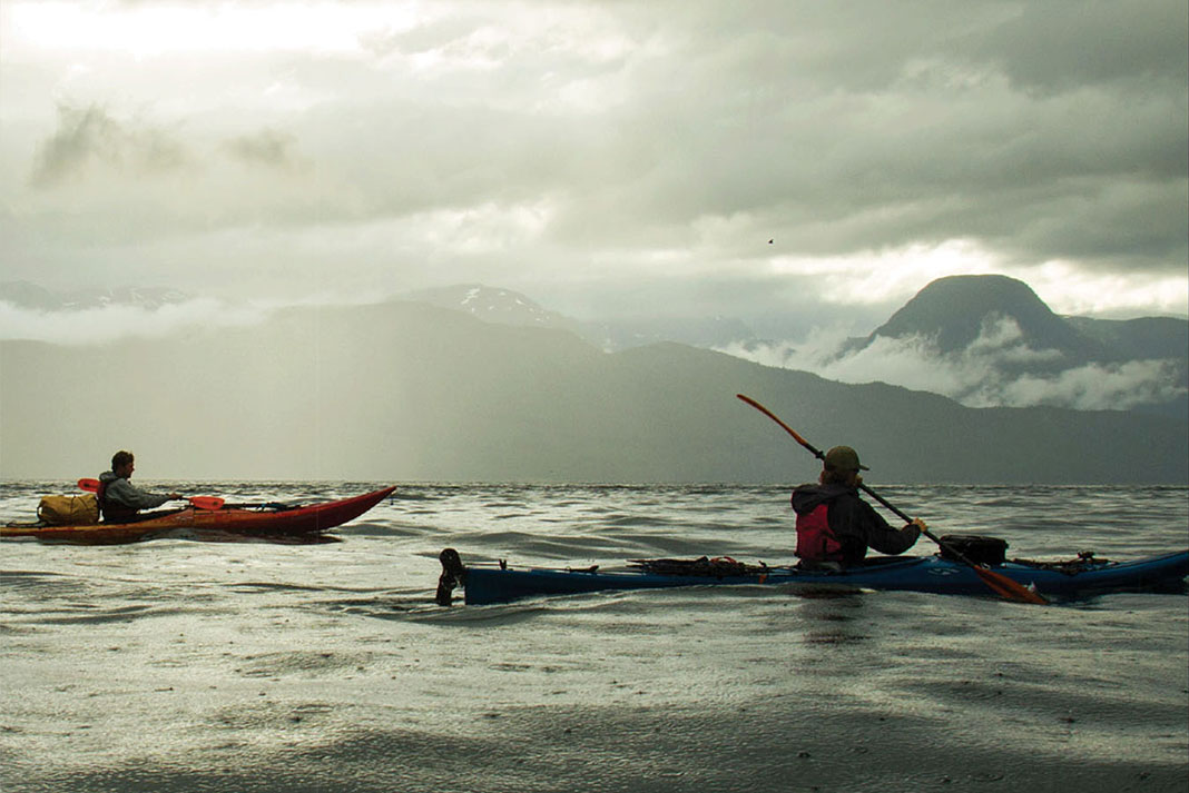
My kayak was full of water. We were over a mile from shore when I made this unsettling observation. Already overloaded with two hundred pounds of food, camping gear and camera equipment, I hadn’t noticed my shrinking freeboard until now. Through my dry suit, I felt something bob against my thigh. With the waves continuously crashing over my deck, I called to Spencer and Daniel to raft up next to me. Pumping furiously, we bailed the frigid North Pacific only slightly faster than it poured in.
Reaching one of Douglas Channel’s scarce beaches, I carefully pulled my boat up on the slippery rocks to drain the flooded front hatch and cockpit, noticing the foam bulkhead between the two was not properly sealed. Still, I was thankful the worst was over. Then the bag containing our satellite phone and tide charts washed out, full of seawater.
With our primary means of communication destroyed (we carried an emergency transmitter for back-up) and our charts ruined, we had a difficult decision to make: return to the small Haisla community of Kitamaat Village where we had begun our trip just hours before, or continue as planned eight days into the remote coastal wilderness of the Great Bear Rainforest.
Adventure—and controversy—in the Great Bear Rainforest
The largest temperate rainforest in the world, the Great Bear covers 70,000 square kilometers along the northern B.C. coast. When we had planned this trip two months before, I realized just how little I knew about this remarkable wilderness, despite its position at the center of an environmental debate surrounding the proposed Northern Gateway pipeline.
If completed, the pipeline will pump oil from the Alberta Tar Sands across Alberta and British Columbia to the Pacific Ocean where it can be loaded into tankers and shipped to Asia. Proponents of the project say it is necessary in order to diversify the markets available for Alberta oil, while opponents claim that it will bring toxic crude through sensitive and pristine ecosystems where a leak would have devastating effects.
Environmental controversy isn’t new in this region. Neither are grassroots initiatives: the actions of small groups of people have already foiled bids to clearcut log, trophy grizzly hunt and open net salmon farm in the Great Bear. Eager to discover the area for myself, I also wanted to share our adventure so that others who couldn’t make the trip would be better informed on the Northern Gateway issue. Packing video equipment, I hoped to document some of North America’s most rare and majestic animals including spirit bears, cougars, grizzlies, dolphins and whales.
“Our sea kayaking experience was essentially zero.”
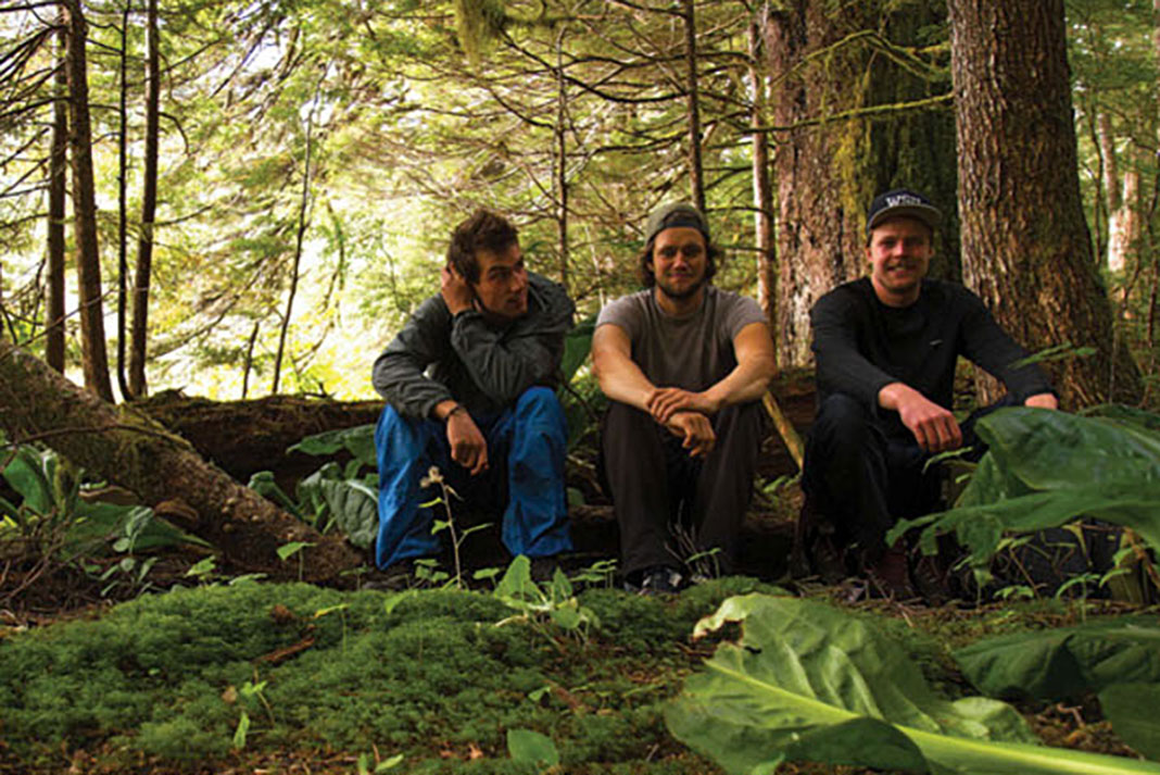
Friends for 20 years, Spencer Taft, Daniel Robb and I grew up within a few blocks of each other. We live much farther apart now, but our shared interest in nature and adventure keeps us close. Taft is pursuing his Masters of Ecology after returning from three months of hitchhiking from Kosovo to Lithuania. Robb spends his summers as a canoe guide in the Northwest Territories and his winters ski patrolling and guiding in British Columbia. He is one of the few people to complete the 20-day, 320-kilometer ski traverse along the Great Divide between Jasper and Lake Louise. Whitewater kayaking since age four, I paddle on the Canadian National Whitewater Slalom Team and train in the steep, beautiful rivers that cascade through the Rocky Mountains.
It was Robb who first mentioned the Great Bear. He told us that, when he took a recent fishing trip to the area, the Native community at Hartley Bay was protesting the plan to ship oil from the mainland through 150 kilometers of narrow, twisting and frequently stormy channels. The proposed route included the area where B.C. Ferries’ flagship Queen of the North crashed into Gil Island and sank on a gusty night in 2006. The Natives claimed that if a similar accident happened involving one of the oil tankers, the resulting spill would devastate the ecosystem their community has relied upon for thousands of years.
Talking it over, we agreed that together we were uniquely suited for an expedition through the Great Bear. I had two decades of kayaking experience, Spencer had extensive knowledge of the flora and fauna we would encounter, and Daniel had expertise preparing for multiday adventures. There was just one little problem—our combined sea kayaking experience was essentially zero.
High spirits, rough water
We started our trip near the city of Kitimat, where the proposed tanker route would begin. An industrial town planned and built by aluminum smelting giant Alcan in the 1950s, Kitimat is not commonly used as a departure point for kayak trips so there’s no paddle shop. Luckily, we found a passionate advocate for the rainforest in Joe Paolinelli, owner of Skeena Kayaking in Prince Rupert. Paolinelli had boats and equipment waiting for us in Kitimat, but in our inexperience we didn’t grab enough waterproof neoprene hatch covers, which is how our satphone arrived at its salty demise.
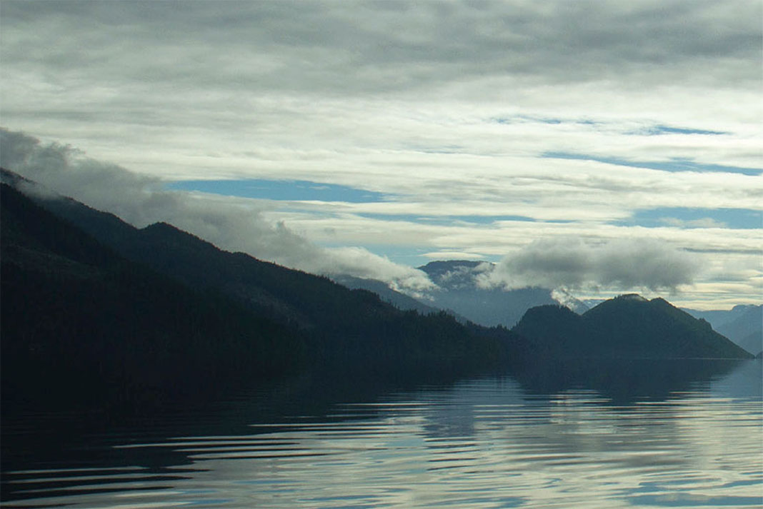
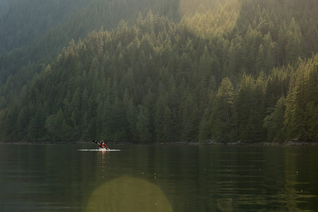
After sealing my leaking hatch with duct tape and a garbage bag, we were in high spirits as we navigated the rough water of Douglas Channel, drinking in the warm air and spectacular scenery. One of the area’s most beautiful features is also one of its most significant hazards—the shoreline is predominantly vertical rock cliffs with impenetrable vegetation beginning at the high tide mark. Getting off the water is often impossible.
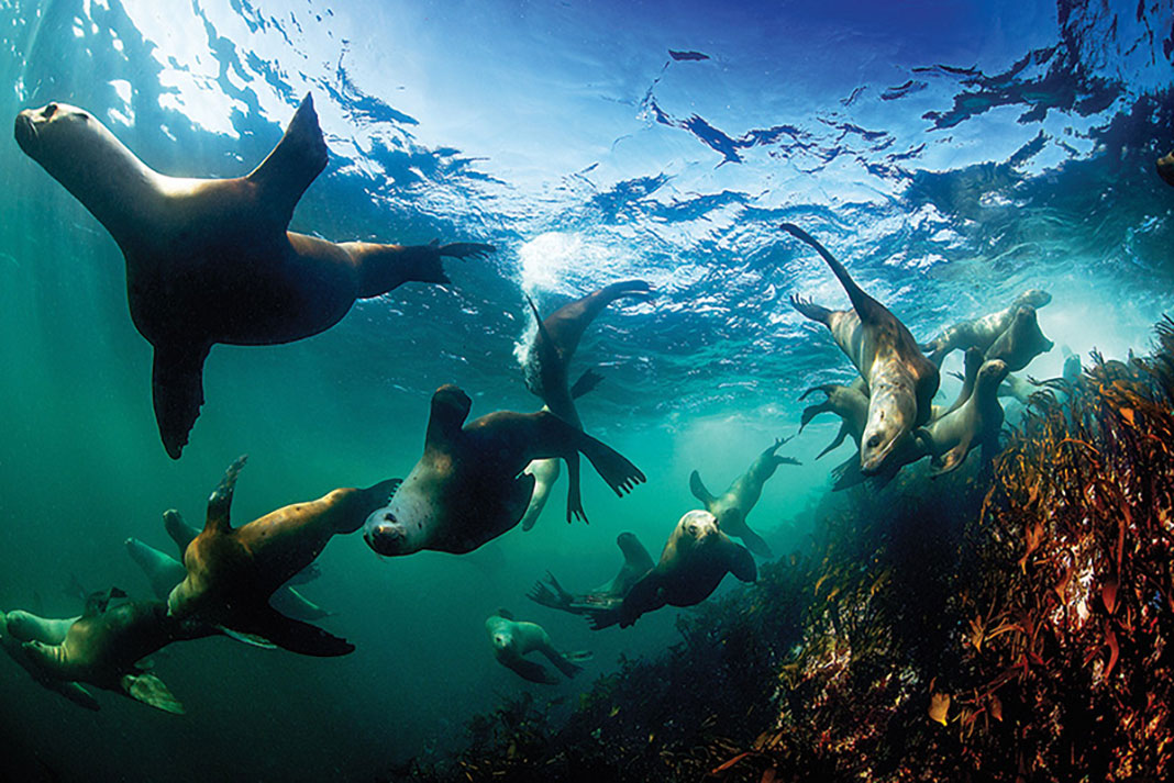
Kayaking through this flooded mountain range, we wondered what might be gazing back at us from the thick curtain of woods. The Kermode, or spirit bear, is a black bear that possesses a recessive gene rendering it completely white. Found only in this area, the ghostly bears feature in Native folklore and the hope of spotting one fishing for salmon spawning up the creeks kept us close to shore.
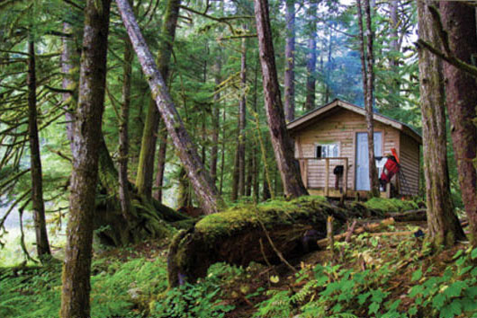

Eager to support our film project, the Haisla community had given us permission to use the tiny trapper’s cabins they have built throughout the region. The cabins are only eight feet by 10 feet and locating them amongst the thick vegetation was difficult. Reaching Coste Island, we couldn’t find the cabin at all and ended up tenting on a cliff overlooking the distant lights of Kitimat.
Nothing dries in the rainforest
The Coste Rocks are 150-foot pillars that rise from the ocean floor to just break the surface as craggy islets. I hoped to film harbor seals hauling out and sunbathing on the rocks so we set off at sunrise to reach them on a favorable tide. Without our charts, we congratulated ourselves for calculating the tidal period using our knowledge of the sun and moon. But we prairie boys soon found ourselves paddling against the current as a thick fog and heavy rain rolled in. As we neared the rocks, dozens of seals slid into the water. I set up a camera and we ate lunch in the drizzle, waiting. But the shiny little heads only stared sulkily at us from the water.
To escape the funnelling wind and waves of Douglas Channel, we turned down sheltered Devastation Channel and pushed on through the fog. Low tide revealed mussel-coated rocks and we aimed for Hugh Creek with mounds of the molluscs on our decks. Paddling up into the fresh water, Spencer pointed into the coniferous jungle and gave a welcome cry, “Cabin!” The wooden cabin stood on three-foot piers above the mossy ground. One tiny window barely illuminated two sets of rustic bunks and an inviting wood stove. Within minutes, we had converted it into a sauna as we steamed mussels and listened to rain drumming on the roof.
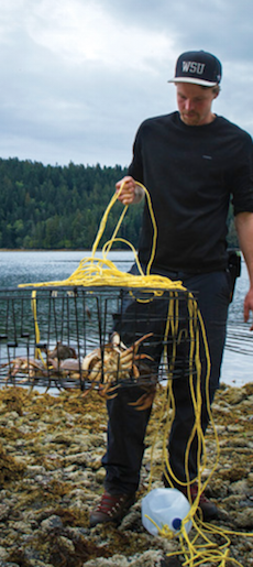
A bright morning revealed three huge crabs in our crab trap and the soggy truth that nothing dries in the rainforest. As the crabs boiled, we watched eagles scanning the confluence of the shallow creek and the ocean for their own breakfasts. Eating from the sea and drinking from the creek, we felt a connection to the indigenous people who have been doing just that, probably right there, for thousands of years.
As hard as it was to leave, we couldn’t resist the allure of a nearby hot spring. Like the verdant forests, the Great Bear’s abundance of natural hot springs owe their existence to the region’s copious rainfall. Rain seeps down through the mountains’ sedimentary bases where it’s heated geothermally, and the hot water is forced back to the surface through natural fissures.
That night we decided to adjust our ambitious route plan. I needed footage of the Great Bear’s wild inhabitants to show others what was at stake, but trying to cover as much distance as possible meant that we hadn’t seen a lot of wildlife. The map showed a lake high up in the mountains behind our cabin. We would spend the next day hiking to it.
Threats to the Great Bear
Oil is not the rainforest’s only threat. When the B.C. government named the Great Bear a protected area in 2006, just 50 percent of the forest was made off-limits to logging, leaving half the old-growth forest at risk. Following a creek that tumbled down from Evelyn Lake, we found ourselves on an old logging road overgrown with willows and young spruce where centuries-old Sitka spruce, cedar and western hemlock would have once reached heights of 230 feet. We were clearly not the only users of this wilderness highway. The dirt was imprinted with wolf tracks as big as our hands and fresh piles of bear scat had us nervously fingering the triggers of our pepper spray cans.
After swimming and fishing in the crystalline lake, we returned to the coast along a game trail littered with half-eaten salmon. Spencer explained how a vital source of these forests’ nitrogen and other nutrients comes from fish carcasses carried into the woods by bears and wolves. Moments later, we climbed over a head-high log and found ourselves face to face with a huge black bear. Luckily, the bear had already filled its belly with salmon and we made it back to the cabin instead of nourishing the trees.
With our own food supply running low, we turned back toward Kitamaat Village the following day. At our cabin that evening, I was restless and frustrated. I had missed filming the bear on the game trail—I still didn’t have what I needed. Wandering down to the beach where I had collected mussels for dinner, I spotted a black bear eating from the exact spot I had been only minutes before! Elated, I ran back to the cabin to grab my camera and my friends. We sat on the edge of the forest and watched our neighbor crack open mussels and sniff at the new scent in the foggy ocean air.
On the final 20-kilometer push to Kitimat, carbohydrate withdrawal was obvious as we talked for an hour about different ways to cook yams. A cold wind, rain, fatigue and hunger had us in low spirits until a dozen dorsal fins popped up in front of us. A pod of Dall’s porpoises had come to investigate and offer us a reminder of why we were out here.
Leaving the Great Bear, I found myself pondering the issues facing this complex wilderness with a newfound clarity, and grateful to have had the chance to journey with my friends amongst the rainforest-cloaked mountains, foraging bears and playful porpoises. I was glad, too, that the trip was more than a personal adventure. Aspiring to share the Great Bear’s story with others enhanced my own connection to this special place. Hauling camera equipment and seeking out opportunities to film may have limited our miles, but it opened our eyes.
Great Bear trip planner
When to go
Mid to late summer has the most stable weather with the least wind and rain. However, keep in mind you are in a rainforest—plan for wet weather. In the spring, runoff from creeks and rivers creates currents that can make getting into the inlets dangerous. Storms plague the region beginning in late September. Expect bugs almost any time of year—a local told us the only insect repellent is winter.
Difficulty
Douglas Channel is renowned for wind and waves. Infrequent landings due to the surrounding cliffs compound the difficulty, making this an advanced route. The deep fjords and foul weather also make communication, even by satellite, unpredictable. Freshwater for drinking is available approximately every 10 kilometers.
Access
The city of Kitimat is accessed by Highway 37 off Trans-Canada Highway 16. There is no recreational boat launch, as the Alcan plant takes up the city’s entire waterfront. The best option is to drive 20 minutes southeast on Minette Bay Road to Kitimaat Village and launch for free at MK Bay Marina. Parking is $5 per day. BC Ferries does not service Kitimat, the nearest ferry ports are Klemtu and Prince Rupert.
Charts/Forecasts
Canadian Hydrographic Series chart 3743 (1:73,000). Find local wave heights and marine weather from the Nanakwa Shoal weather station at weather.gc.ca.
Guidebook
The Wild Coast, Volume 2 by John Kimantas (Whitecap Books, 2006) is excellent and has detailed maps and information on many routes in the region.
Guided trips
Albacore II Charters offers mothership services.
The Gitga’at Native community at Hartley Bay offers guided trips and accommodations.
 This article was first published in the Summer/Fall 2013 issue of Adventure Kayak Magazine.
 Feature photo: Paul Manning-Hunter


")


