Home Blog Page 489

Historic Fur Trade Routes

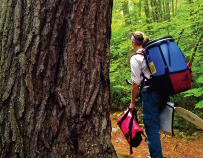
Photo: Beth Kennedy

This canoe routes destination article originally appeared in Canoeroots and Family Camping magazine.

The fur trade lasted three centuries, opening up North America. The couriers-du-bois voyageurs and Natives who traveled these waterways shaped modern transportation corridors, settlements and cultures. Retrace their paddle strokes along trade routes that once connected Montreal to Oregon and Hudson Bay to the Gulf of Mexico.

Lake Champlain

NEW YORK, QUEBEC AND VERMONT

Samuel de Champlain discovered this lake in the early 1600s after establishing New France. With the Richelieu River to the north and Hudson River to the south, it was part of a fur trade thoroughfare connecting the St. Lawrence to New York. The waterway was also a pivotal battleground during the War of 1812. Sandwiched between the Adirondacks and the Green Mountains, enjoy paddling Lake Champlain’s 80 scenic miles from end-to-end over seven days. The Lake Champlain Paddlers’ Trail consists of more than 600 campsites and 39 access points, providing endless route possibilities. www.lakechamplaincommittee.org

French River

ONTARIO

Ojibwa Indians named the iconic French River in the 1600s because it brought ex-plorers like Etienne Brulé. Traders would soon follow, transporting furs from western Canada through this corridor that links Montreal to the Great Lakes by way of the Ottawa and Mattawa rivers. Now a Canadian Heritage River, the French offers canoeists 70 miles of paddling through Canadian Shield and provincial parkland. Choose to navigate the abundant family-friendly whitewater or experience portages that have remained unchanged for over 300 years. www.ontarioparks.com

Des Plaines River

ILLINOIS

In 1670, French explorer René-Robert de La Salle set out on an expedition to secure an inland trade route connecting Montreal and New Orleans. The Des Plaines

River provided traders passage between Lake Michigan and the Mississippi. It runs 95 miles south through Illinois and offers paddling among some of the rarest remaining natural prairie. Forest and nature preserves line its banks—habitat for cormorants, egrets, herons and small mammals. Isle la Cache in Romeoville is home to a fur trade interpretive center and has one of nine canoe-only access points along the river.

www.lcfpd.org

York Factory Express

MANITOBA

York Factory served as the Hudson’s Bay Company’s Northern Department headquarters on Hudson Bay and operated as a trading post for over 270 years. It was the easternmost point of the York Factory Express, a trade route that connected the Oregon coast with Hudson Bay. The final leg of this traditional artery carried voyageurs from the Norway House outpost at the northern reaches of Lake Winnipeg to York Factory. This remote whitewater canoe route takes paddlers on a three-week, 375-mile trip past abandoned train lines and fur trade posts, old gravesites, pictographs and forgotten settlements. www.paddle.mb.ca

Columbia River

OREGON AND WASHINGTON

At the other end of the York Factory Express is the Columbia River. In 1807, fur trader, surveyor and mapmaker, David Thompson set out from the river’s source deep in the Canadian Rockies at Rocky Mountain House to explore the Columbia’s path to the Pacific. Meanwhile, American Fur Company owner, John Astor, established a fur trading post at modern day Astoria, Oregon, where the river meets the ocean. Retrace some of Thompson’s journey on The Lower Columbia River Water Trail—a 146-mile route from the Bonneville Dam past volcanic cliffs, wildlife refuges, museums, memorials and lighthouses to the Pacific Ocean at Astoria. www.columbiawatertrail.org


 This article originally appeared in Canoeroots & Family Camping, Fall 2012. Download our freeiPad/iPhone/iPod Touch App or Android App or read it here.

Sea Kayak Review: Tiderace Xplore-S

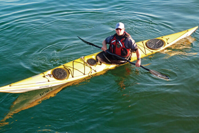
Man paddling yellow sea kayak
Go xploring. | Photo: Keith Wilke

Based in Penrith, England, Tiderace Sea Kayaks have rightfully become synonymous with performance planing-hulled, rough water play designs through their Xcite, Xtra and Xtreme lines.

Introduced in 2009, the Xplore series fills the needs of expedition-minded paddlers with four meticulously scaled sizes. They’re already gaining a reputation of their own, making some significant journeys like James Baxter’s 3,100-km trip down the coast of Norway.

Tiderace Xplore-S Specs
Length:17′ 5″
Width: 20″
Weight: 53 lbs
Paddler: 150–200 lbs
Dry storage volume: 194 L
MSRP: $4,449 Hardcore Layup / $5,049 Hardcore G Pro Layup

tideraceseakayaks.co.uk

With a narrow, 20-inch beam, low foredeck and very low profile aft deck, the Xplore-S is the smallest size in the Xplore range. The lines have a refined quality that showcases the CAD (computer aided design) expertise of Tiderace designer and founder, Aled Williams. If Williams’ name sounds familiar, it should—he’s made memorable appearances cartwheeling a sea kayak and surfing the Falls of Lora in the This is the Sea DVD series.

The Xplore-S offers great speed with few sacrifices in mobility. Downwind, it is able to catch fast-moving wind waves without hitting the dreaded bow-wake—a common companion to the upswept prows of British kayaks— that signifies the final threshold of speed. This puts the limits of speed on the paddler where it belongs, rather than on the kayak.

Putting the Xplore-S on edge offers significantly increased mobility with solid and predictable results. With a shallow V hull and moderate chines, it hangs on edge very comfortably even in lumpy conditions. Pivoting 360 degrees on flat water requires little edge, and the kayak comes about quickly. Playing in short-period surf on the Great Lakes, there was no wobble when we heeled it over to the chine and spun around on the backs of the waves to get in position for the next ride.

Surfing any sea kayak on waves taller than three feet will inevitably result in pearling or broaching, but the Xplore-S gives plenty of warning prior to the event. With subtle shifts in weight, edging and rigorous application of directional rudder strokes, we could control broaching and fun nose-diving, or back off from a terminating ride.

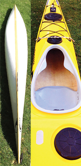
The Xplore-S features Tiderace’s signature sloping deck at the cockpit, offering ample legroom for a more upright leg position when dynamic forward paddling, and the ability to grab with your knees when needed for edging and rolling.

Hull and top of yellow sea kayak
Photos: Keith Wikle

Tiderace has made a new industry standard with its composite construction technique of using biscuit-tin hull-to-deck seams that are then glassed inside and out. Williams has also pioneered the use of a resin-filled core between multiple layers of fiber material.

This creates boats that are stiff without being brittle—as I can attest after surfing bow-first into a pier and emerging unscathed—and sturdy without being excessively heavy. Consistency is Williams’ other great asset—we’ve never seen a Tiderace that didn’t display superlative construction.

Most expedition kayaks pay lip service to the LV market while intending to appeal to a much wider range of paddler weights and sizes. Tiderace has offered a rare thing, a truly scaled-down version of a fast and mobile expedition kayak that is at home on the open water, surfing the beach or ducking behind rocks and through arches.

Clever curves

Subtle changes in volume through the bow and stern give the Xplore-S both speed and maneuverability when edged.

All-day play

The molded seat pan and separate adjustable backband of the Xplore-S offer great comfort off the shelf, but both can be repositioned further forward or back to suit.

This article was first published in Adventure Kayak‘s Summer/Fall 2012 issue. Subscribe to Paddling Magazine’s print and digital editions here , or browse the archives here.


When it comes to sea kayaks, Kalamazoo, Michigan-based Keith Wikle is pretty fussy. It took an Xplore-S to pry him out of his vintage Nigel Foster Silhouette.

Tech: Messages from Space

Tech: Messages from Space

This article on adventure tech was originally published in Adventure Kayak magazine.

When Adrian Meissner, the operations manager at Boundless Adventures, an outdoor adventure center located across the river from the Adventure Kayak magazine office, sends a group into the backcountry, he does so with both a GPS satellite communicator and a satellite phone.

“For one season a few years ago while we were waiting for sketchy Globalstar satellite phone service to improve, we purchased a couple SPOT satellite messengers for back up,” Meissner says. “Even after we switched to Iridium phones with a stable voice connection, we still use both technologies together.”

The four-button simplicity of the early satellite message devices turns out to be their most limiting factor. Users are given only three options, two of which you pre-program in advance and one is a direct line to the cavalry via the GEOS international search and rescue center.

The challenge is the one-way nature of these devices. You must think of all possible situations in advance and create a plan for what each predetermined message might mean in order to use them effectively.

Meissner’s staff team have agreed that the OK button and its mes- sage means the group needs logistical help. “If we get this message and we see the location of the group is on a shuttle road, we know the situation is not personal injury or illness and we’d suspect van trouble and begin to react accordingly.”

Meissner uses the Help button for personal injury or illness situations, setting into action a different response protocol. In either case, Meissner’s staff then turn to their satellite phones to further troubleshoot the problem and formulate a plan.

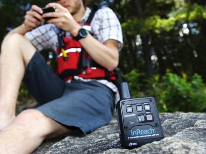
Global two-way satellite communicators, like the DeLorme inReach, do on their own what the magic orange boxes have always done—send preplanned messages, coordinates and tracking. However, when you sync the inReach via Bluetooth to either an Android or Apple mobile device running DeLorme’s free Earthmate App you have so much more. You can write 160-character messages and send them to anyone in your phone’s contact list and receive their replies just like regular texting, except via satellite rather than a cellular network. The app also allows you to post to Facebook and Twitter and you can install DeLorme’s terrain maps and downloadable NOAA nautical charts.

For Meissner, two-way messaging is a game-changer. “This may prove even better than our satellite phones. With texts you have a record of the conversation, you’re not scribbling things down and you have time to think and plan your response, rather than rushing to reply because you’re worried that your call may be dropped.”

This article originally appeared in Adventure Kayak, Fall 2012. Download our free iPad/iPhone/iPod Touch App or Android App or read it here.

Safety: Don’t get hit by a ship

Safety: Don't get hit by a ship

This article on safety was originally published in Adventure Kayak magazine.

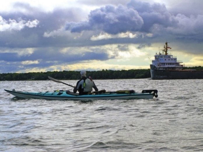
Few paddlers have shared the water with container ships, ferries and tugs and never pondered the frightening, one-sided consequences of a collision. The watery rules of the road enforced by the Coast Guard—bluntly known to lawmakers as Collision Regulations—require that large, motorized vessels yield the right of way to human-powered craft like sea kayaks. But in reality, “might has right” is a more appropriate adage.

The cardinal rule for kayakers is to minimize time in busy shipping channels. If you must venture into busy waters, be aware of ships’ locations and directions of travel, as well as their inherent limitations to visibility and maneuverability. Never take for granted the speed at which large freighters can travel—in excess of 20 knots in open water.

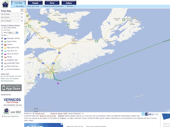
Now, however, sea kayakers have a secret weapon for negotiating shipping lanes. The University of the Aegean in Greece maintains a website that monitors large vessel traffic worldwide, including all coastal areas and major inland waterways like the Great Lakes. Marinetraffic.com provides the real-time position and projected course of cargo ships, tankers, ferries, high-speed craft, tugs, yachts and fishing vessels on Google Maps, including vessel speed and heading, and the ability to track a ship’s progress for up to 48 hours. It also provides wind speed and direction, gleaned from federal sources like the National Oceanic and Atmospheric Administration (NOAA).

The website gathers information from vessels’ automatic identification system (AIS). The International Maritime Organization requires all vessels over 299 gross tons to carry an AIS transponder on board, which includes the boat’s name, dimensions, home port, operator and voyage details, and constantly relays position, speed and course to satellites. Besides improving boater safety, University of the Aegean engineers designed the website to develop navigational algorithms to improve shipping efficiency and correlate ship traffic with pollution patterns.

MarineTraffic.com

Of course, web-based, electronic technology has limitations for paddlers. Marine Traffic offers an application for iPhone users, but unless you’re willing to dig out your phone while you’re on the water, you’ll be guessing the location of ships. Still, since the majority of traffic concerns occur near urban areas, Toronto-based sea kayak instructor David Johnston says the ability to live-track vessels is a huge safety advantage.

“We get international ships in the harbor here all the time,” he says,“so this could be fun to play with from a tourist on the water perspective. The other angle would be if you were planning a crossing through shipping lanes. You could check the app to see if any big stuff was creeping up around the corner.”

Visit www.marinetraffic.com to plan your next trip through a shipping lane.

This article originally appeared in Adventure Kayak, Fall 2012. Download our free iPad/iPhone/iPod Touch App or Android App or read it here.

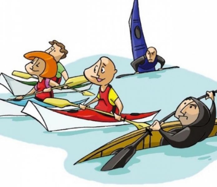
Rock the Boat: Why is John Dowd Lonely?

Illustration: Lorenzo Del Bianco
Rock the Boat: Why is John Dowd Lonely?

There was a time in the early ‘90s that the Clayoquot Sound beach on which I live was host to half a dozen private groups of kayakers on any one evening. Sometimes, as many as 50 campers vied for a spot to put their tents during the summer months.

During the summer of 2011, it was a very different scene. Calm seas and mild weather did not entice the numbers of previous years. Labor Day brought silky seas and warm, sunny days but the only campers on our beach were hikers dropped there by water taxi.

From April to September, the groups that did arrive were mostly instructor training or outdoor programs run by colleges and high schools. The rest were a smattering of commercial tours with their distinctive green and white tarps and customers who always look just a little out of place.

What’s going on?

To answer that question, I have to go back 10 years to a consulting job I did for a retail store that sold dive gear in one half of the shop and sea kayaks in the other. I asked the staff what they were really selling on the dive side of the shop. After much discussion they agreed they were selling a sense of belonging. Belonging to a society whose members had undergone a rite of passage. They had completed the courses and received the blessing of their peers. They were certified divers.

So what about the sea kayaking side of the shop? There they agreed that they were selling free- dom. It was noted to the surprise of the shop’s owners that the crossover was barely 15 percent. This difference isn’t one of chance. When sea kayaking began to take off in North America

in the 1980s, I was in the midst of it as a publisher, retailer and manufacturer. The sport’s popularity at that time was due in large part to a conscious focus upon accessibility to ordi- nary folk, especially women and families.

We realized that we had to avoid the macho whitewater attitude with its over-emphasis on technique. Rolling, surveys told us, was a turn-off for most of our customers, and not much use for the most common emergency situation in which a paddler becomes gradually overwhelmed by conditions.

We had the British as an example of what not to do. Across the pond, a thriving post-war kayak industry had been reduced to a tenth of its glory of the ‘50s and ‘60s. Instructors bent on right and wrong had scorned and certified the kit-built boat people and their simple craft out of the market, replacing them with heavy West Greenland-style boats that appealed to a very different crowd. From family activity, “sea canoeing” became 90 percent young males.

I am convinced that the reduced number of serious sea kayakers who appear on our beach each year has to do with the shift of sea kayaking from a freedom-centered activity to a belonging or following activity. The first question a new member to a local sea kayak club was recently asked by other members was,“What level (of certification) are you?”

New books on sea kayaking do not emphasize seamanship, which is at the heart of the activity, but focus in excruciating detail on an array of marginally relevant whitewater strokes and a forward stroke taken straight from flatwater racing. The distinction between surf kaya- king and sea kayaking has become blurred. The mood has changed.

I predict that those who have brought about these changes will find themselves regulating a smaller and less freedom-loving group. Such few kayakers who make it out to our beach under their own power will be the remnants of an old guard I’ve come to know and like so well.

We can talk about life, not just levels.

John Dowd is the author of the classic text, Sea Kayaking: A Manual for Long-Distance Touring, and paddled from Venezuela to Florida in 1977, long before kayakers carded each other.

This article originally appeared in Adventure Kayak, Fall 2012. Download our free iPad/iPhone/iPod Touch App or Android App or read it here.
Paddling at Frontenac Provincial Park

Watch this episode of Rapid Media TV to learn about Ontario’s most southern wilderness park, Frontenac Provincial Park. We learn from Mark Hall how his short boat designs with Delta Kayaks are making waves in the industry and Scott MacGregor show you how to make sure your boat makes it to the water and back.


Life Jackets For Your Dog

Check out these PFDs and lifejackets for your dog from Ruffwear, reviewed by the Canoeroots team. 

French River Canoe Trip

This is a Canoeroots Digital Extra Feature from the French River in Ontario, Canada. We spent 4 days with Black Feather enjoying this historic river, meeting families from all over the world and find out why they chose this river trip (and why you should too!).


Read more about family friendly river trips by clicking here

Three-Hundred-Year-Old Temagami Red Pines At Risk

Photo: Conor Mihell
300-year-old red pine at Wolf Lake. Photo: Conor Mihell

For longtime Temagami canoe-tripper Brian Back, the prospect of a new provincial park encompassing Wolf Lake, a Windex-clear lake surrounded by a stark quartzite shoreline and a forest of old growth red pine, was “almost a no-brainer.”

Wolf Lake is the scenic highlight of a canoe route weaving in and out of Chiniguchi Waterway Provincial Park, a 9,368-hectare protected area of lakes and small rivers east of Sudbury, Ontario. A Ministry of Natural Resources (MNR) report in 1990 concluded that Wolf Lake “may be the largest remaining contiguous, old-growth red pine dominated forest in North America,” with trees up to 300 years old. Summer camps have fl ocked to the area for decades, along with throngs of recreational canoeists looking for an easy escape.

Despite all this, Wolf Lake isn’t protected. Things looked promising in 1999 when Ontario’s Living Legacy, a government attempt to complete the province’s network of protected areas, established the Chiniguchi park and pegged Wolf Lake as a Forest Reserve—-essentially a park-in-waiting designation that allows mining but outlaws forestry.

Wolf Lake was expected to roll into the waterway park when pre-existing mining leases expired. That’s why Back, the founder of Ottertooth.com, a northeastern Ontario canoe-tripping and environmental website, was shocked
last summer to learn that the MNR planned to revoke Wolf Lake’s Forest Reserve status to more actively promote mineral exploration and, by association, open the area to commercial logging.

Back suspects it was pressure from the mining industry that caused the MNR’s sudden about-face. Developers don’t like parcels of land in regulatory limbo, says Back. Forest Reserve status doesn’t impede exploration activities for Flag Resources, the Calgary-based junior mining company with leases surrounding Wolf Lake, but the uncertain land designation can spook the investors it needs to fund its work.

Regardless of Flag Resources’ 30 years of exploration in the area having turned up no tangible prospects, MNR offered to exchange 340 hectares surrounding Wolf Lake for 2,000 hectares of protected land to be tacked onto the Chiniguchi park elsewhere. According to Bob Olajos, the secretary of the Friends of Temagami conservation group, this is hardly a fair trade. “What we have at Wolf Lake cannot be replicated elsewhere,” he says.

Surging public outcry put the heat on the provincial government to revisit the issue. Last December, the Friends of Temagami and its sister organization, Toronto-based Earthroots, spearheaded a campaign that barraged the provincial legislature with over 1,000 faxes opposing the government’s plans to scrap the Wolf Lake Forest Reserve. In February, 17 conservation organizations and businesses, including Friends of Temagami, Earthroots, Paddle Canada, Camp Keewaydin and the Canadian Parks and Wilderness Society, formed the Wolf Lake Coalition to push for its protection.

Minister of Natural Resources Michael Gravelle insists the province “struck a fair balance” when they decided to retain the Forest Reserve in March. Th is protects Wolf Lake from logging but keeps mining prospects alive.
“It’s the world’s largest old-growth red pine forest. Th at’s the hook,” says Olajos. “There’s a hole at Wolf Lake, right in the middle of this great forest. We want it protected.”


This story originally appeared on page 15 of the Early Summer issue of Canoeroots & Family Camping magazine. Read the entire issue here.

Deliver Me From Ego

Photo: Larry Rice
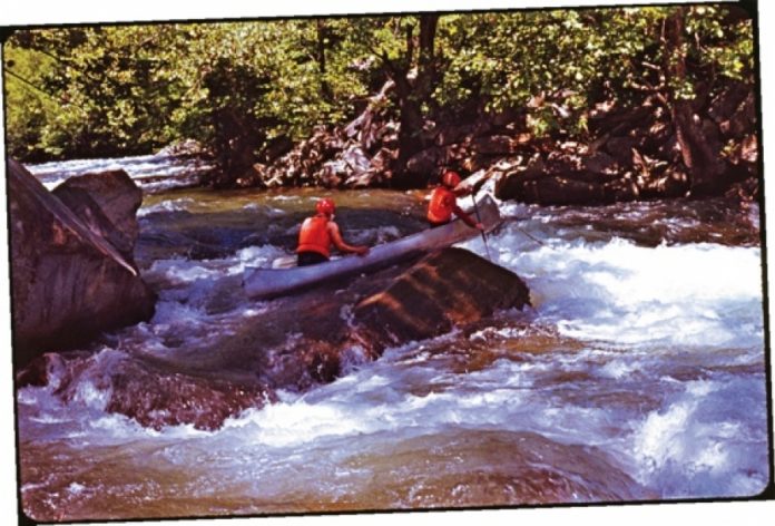
Canoeing the Chattooga in 1975. Photo: Larry Rice

It was spring, 1975. I drove south with a handful of friends from Chicago to tackle the raging river that author and poet James Dickey had mythologized a few years earlier. We were among a huge wave of city slickers making a pilgrimage to north Georgia’s Chattooga River after seeing the disturbing and powerful movie, Deliverance.

Like many of our fellow adventureseekers, we had no idea what we were getting into.

Before the 1972 release of this AcademyAward-nominated film, only a small number of paddlers had explored the Chattooga’s remote, thickly wooded gorges. However, in 1974, due in large measure to its abrupt and unexpected fame, the Chattooga was designated a National Wild and Scenic River and boating use skyrocketed to roughly 21,000 float trips per year. Not surprisingly, a fair share of these giddy rivergoers were ill-informed and ill-prepared. During the year after Deliverance appeared in theaters, 31 people drowned while attempting to paddle the same stretch of river featured in the film.

Photo: Larry Rice

“Hey, what happens if we flip this thing over?” —Bobby, Deliverance. Photo: Larry Rice.

We knew none of this as we camped peacefully along a manageable upper stretch of the Chattooga. The following morning we entered Section III—a 13‑mile run of class II–IV drops and ledges. We endured several capsizes and bruising swims, loaned wetsuit jackets to two other canoeists we found on the verge of hypothermia and helped evacuate a kayak party that had suffered a near drowning.

One of our canoes, my buddy’s prized 17-foot aluminum Grumman, never left the river. It remained wrapped like a shiny pretzel around a mid‑stream boulder between the vertical rock walls of the Narrows, a sobering reminder of our arrogance and ignorance.

Not even knowing it was there, we miraculously stayed upright through notorious Bull Sluice, a killer class IV, before reaching the take-out in the dark. Humbled, bloodied and chastised, our only consolation was that we had finished the trip in better shape than Burt and Jon.

Now, decades later, I hope I’ve learned at least a few things to help smooth those choppy waters. But this I confess: when I think of returning to the Chattooga, I can’t shake a little lingering dread.
Still, the remarkable thing about river tripping is also my inspiration for a sequel: no two runs are ever alike. Which means that one day I might be delivered down the Chattooga with a smile on my face instead of an arrow in my ego.


Buena Vista, Colorado-based Larry Rice runs rivers about 100 days each year. The next time he tackles Bull Sluice, he’ll be counting on skill, not luck.


This story originally appeared on page 8 of the Early Summer 2012 issue of Canoeroots & Family Camping Magazine. Read the entire issue here.