The Georgia coast is home to a series of 15 barrier islands protecting the second largest area of saltwater marsh in the United States. Over a third of all the coastal wetlands on the east coast of the U.S. are found in Georgia.
Rivers emptying into the coastal plain mingle with unusually large tides creating a dynamic nursery for coastal wildlife of all kinds and a perfect destination for kayak touring.
An ideal spot to take in the full variety of the Georgia Coast is Cumberland Island. On Cumberland you’ll find the longest undeveloped stretch of beach in coastal Georgia, large areas of salt marsh, mature maritime live oak forests, herds of wild horses and historic estates with ruins dating from the Gilded Age.
Paddling access to Cumberland is best made from nearby Crooked River State Park and permits are available from park headquarters in St. Marys
Diversion
Singleton’s Seafood Shack in Mayport, Florida is well worth the drive. Singleton’s serves up freshly caught fish and cold beer, with fish camp vibes and friendly neighborhood cats.Outfitters
Kayak equipment and coastal touring advice are available at Savannah Canoe and Kayak (savannahcanoeandkayak.com) and Sea Kayak Georgia (seakayakgeorgia.com).Wildlife
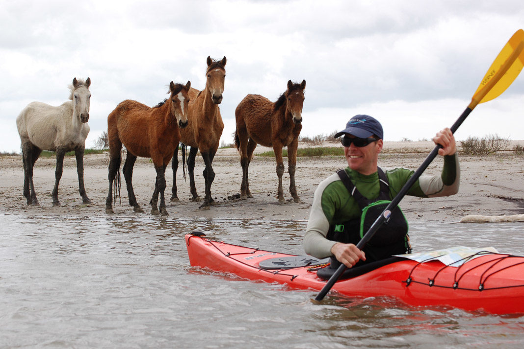
More than 150 feral horses are descendants of animals kept on the island by the Carnegie family. Best viewed from a distance, they have been known to kick and bite visitors who get too close.Beware
The Georgia coast is a dynamic tidal environment and sees the second highest tides on the East Coast. Proper tidal planning is essential to avoid paddling against strong currents or wading through a sea of mud.Did You Know
Cumberland Island’s 18-mile stretch of undeveloped beach is an important nesting site for the endangered loggerhead sea turtle and responsible for a quarter of all turtles hatched in Georgia.
Regular ferry service for hikers connects the mainland to the island but doesn’t transport kayaks, so paddlers need to make the trip under their own power.
If you have a half day
Launch from the boat ramp at Crooked River State Park and explore the wetlands surrounding Grover Island north of the park. Plan your day around a high tide so you can explore deep into the marsh, but head back to the main channel before the receding waters leave you high and dry.
If you have a day
Explore the historic Plum Orchard Mansion on Cumberland. From the Crooked River State Park boat launch paddle east down Fancy Bluff Creek, cross the main channel of the Cumberland Sound and into the Brickhill River. Paddle upstream on the Brickhill River to the public dock. Free guided tours available daily.
If you have a weekend
Basecamp at the Sea Camp campground and explore the island on foot and by kayak. Cross the Cumberland Sound from Fancy Bluff Creek and land at the Sea Camp dock. Check in at the park office and ask permission to cache your kayaks nearby. Sea Camp offers secluded campsites in a mature maritime coastal forest of live oaks and saw palmetto. It’s a perfect jumping off spot to explore the beach or the nearby Dungeness ruins. Permits are required.
If you have a week
Experienced kayakers can link a stay at Sea Camp with a stop at the Brickhill Bluff backcountry site. After a night at Sea Camp load your kayaks for a trip up the Brickhill River. Make sure to bring equipment to hang your food to protect it from the local raccoons. From Brickhill you can hike to the historic First African Baptist Church and explore the north end of the island. Paddlers looking to circumnavigate Cumberland can continue on.



For starters, the only outfitter in the area with experience with this trip is Adventures Up The Creek (22 years with a C.U.A for paddling to Cumberland Island) in St. Marys, GA. And, because you missed that piece of information, you have some bad information in this article — the kind of information that creates problems for the NPS every week of the year with people coming down here with the wrong equipment, bad information and a half-baked plan.
Paddling around Grover’s Island takes at least 6 hours and is way more marsh and kayaking than most people want in one day. AND, you don’t paddle “around” high tide here; you paddle with very specific plans where the tide is concerned. The big problem with the Grover’s Island loop (which shouldn’t even be on the CRSP park trail map) is that it is so long there’s no way to do it without ending up paddling against the tide for the last mile or two. The tidal currents in the Crooked River can exceed 7 kts. I had a couple of experienced kayakers — with a map — trying to go over to Harriett’s Bluff and back (a 3.5 hour trip), but they ended up behind Grover’s Island with the tide pulling them to the east. They couldn’t fight the currents, so they surrendered to them and went around the Grover’s Island loop. They said they planned on getting out of the kayaks at Harriett’s Bluff, but after 5 hours I went looking for them and ended up towing the lady back the last mile.
On tides, a small group of paddlers from the U.S.C. & K. Team ignored Jennifer’s tide briefing, stating that they were “world class paddlers” and would be back by noon the following day. The next day, they were picked up and returned to Crooked River State Park (CRSP) by a fishing boat who found them trying to fight the tidal currents to make it back by noon. They had made no headway. The currents around here are too swift to make headway against for very long. Even if you could, you can always count on coastal winds being unpredictable. You cannot paddle against the tide AND the wind here — and the only part of that you can control is when in the tide cycle you launch.
The trip over to Plum Orchard must be done in such a way that you are on Cumberland Island at low tide. That’s not Fancy Bluff Creek, that’s the Crooked River — even the part at the dividings. Also, that’s not the Cumberland Sound you’d be crossing; that’s the Cumberland River and part of the ICW. The Cumberland Sound is on the South end of the island and is solid L-3 kayaking. You do not reach Sea Camp via Fancy Bluff Creek; and, if paddling from Crooked River State Park, you wouldn’t cross the Cumberland Sound. The trip from Crooked River State Park to Sea Camp is all river and all outgoing tide (assuming you plan your trip properly) — taking about 3.5 hours with the tide in your favor. If you’re camping, the ideal route to Sea Camp is from St. Marys. That trip does cross the north edge of the Cumberland Sound, but it’s only a 2 hour paddle. People really don’t need to be encouraged to rent a kayak and go over to Cumberland Island on their own unless they have intermediate sea kayaking skills. During the course of a day — and certainly over a period of days — something will change with the weather that may create L-3 conditions (thus anyone encouraged to go out there should have those kinds of skills).
Paddling from Sea Camp to Brickhill Bluff is about a 4-hour trip if you do it right — which means being just south of the Crooked River at high tide. Circumnavigating Cumberland Island requires negotiating the St. Andrews Sound, the mouth of Christmas Creek, miles of ocean and then the Cumberland Sound and jetties. Unless you’re an endurance paddler with L-3 — L-5 skills, you’d have to do that in little chunks — which means illegally camping within the National Seashore. Circumnavigating Cumberland Island is something some of our adventure racing guides do for a challenge, but it’s not really a “thing” people do — or need to do.
Honestly, this looks like it was written by someone who looked on Google Earth or Google Maps for a general idea of where things were and phoned it in — or someone who may have been here once (with some sketchy planning) and gotten away with something. People get away with things around here and think that means they know what they’re doing — like taking canoes over to Cumberland Island or paddling without knowing the tides, etc. There was an outfit down here a while back (who did circumnavigate the island with guests)…and I’d occasionally pass them as I was leaving the island and they were arriving. That means that their tide information was off or they didn’t understand what they were doing. These were all ACA types, so they could have learned what they needed to know and should have known.
We’ve also had ACA I.T.’s plan classes here…including circumnavigating the island…and then get into trouble on the north end of the island. No CUA, no proper planning (in a class that’s all about planning and safety), no local knowledge of water that changes after every storm, etc… Having certs or credentials is no substitute for specific knowledge and common sense. This article is full of holes, bad information — and it’s irresponsible considering the conditions commonly experienced around Cumberland Island.