Amid the bouts of seasickness that overcome my gut like the swells that pitch and roll this rattle- trap ferry, I feel a kinship with Joey Smallwood. The man responsible for bringing Newfoundland into Confederation in 1949 wasn’t much of a seafarer. He once spent days seasick in the hold of a hired schooner as part of a hare-brained plan to unionize remote coastal fishers and preach his political ideals. Since fishing season lasted from break-up to freeze-up, Smallwood decided that a wintertime voyage was best. When the captain dismissed him for a lunatic, the soon- to-be leader of the province disembarked and continued on his own, walking the ice of the island’s bottom half—locally known as the Southwest Coast.
Adventure Kayak editor Tim Shuff, photographer Ryan Creary and I came to Newfoundland with more rational plans. We sea kayaked 200 kilometres of the Southwest Coast, visiting many of the long-lost com- munities Smallwood attempted to unite. For 11 mostly glorious days in September our trip was nothing like Smallwood’s, with no high seas adventure, pack ice or blinding blizzards. But now, hanging over the stern of the coastal ferry as it retraces our route from Francois to Rose Blanche, I can’t help but feel fellow to a man who got to know the people of the Southwest Coast in its heyday, even if it was in the most manipulative way.
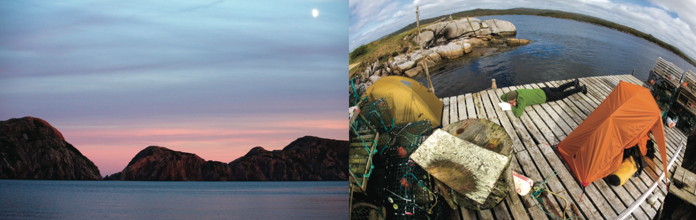
It’s fitting after a whirlwind journey by air and road to get here that Tim, Ryan and I find ourselves hunkered down with too much time on our hands scant kilo- metres from our launching point. We hummed and hawed in the fog at a wharf in Rose Blanche, New- foundland, while the local fishermen looked on with incredulity. Our general plan to spend the better part of two weeks paddling to the isolated outport of Fran- cois was as crazy to them as our immediate intention of launching into the three-metre seas punishing the breakwater. But we set off anyway.
An hour later we washed ashore on a decomposing boat slip in the old village of Petites, population two, where gale force westerlies held us captive for two nights. Petites was once one of the hundreds of “out- port” communities spread out along Newfoundland’s 10,000 kilometres of rocky perimetre. Few faces peer from the windows of the 20-odd houses remaining
atop rickety two-by-four stilts at the water’s edge or clinging to the treeless, granite barrens of uptown. Despite its mid-latitude location, the landscape in this corner of Newfoundland is an arctic-like, windswept and glacier-carved expanse of bogs, domes and fiords.
At Petites we befriend one-half of the community’s resident pair who tells Tim and I how he returned to his birthplace in 2002 and bought a modest two-storey clapboard house for $2,700. A year later, the province sent in its last supply tanker to feed Petites’ diesel generators and most of the citizens collected $80,000 resettlement payouts. In choosing to stay, the man says the government paid him $12,000 for the house it now leases to him for one dollar a year. Petites’ last holdouts cook with propane and go to bed early. They let their subscription to satellite television expire and watch the caribou in- stead. The next morning, we’re paddling before the first curls of woodsmoke rise from their chimney.
There are about 90 kilometres of coastline to paddle between Rose Blanche and Burgeo, made up of rocky jetties, serpentine inlets, bedrock headlands, steep islands and, in the last half, sweeping sand beaches. Leaving Petites, we surf a residual swell and building wind waves past the ghost towns of Westport, French Cove and Cinq Cerf – outports that Smallwood once tried to unionize. The coastline is pleasantly diverse yet somewhat unremarkable, except for the portion between the active outports of La Poile and Grand Bruit where 300-metre-tall granite cliffs stretch far inland.
Wind holds us up for another day-and-a-half and we make tracks as soon as the swell is half-manageable, skirting the leeward side of a labyrinth of reefs with ominous names like The Smoker, The Jumper and The Galloping Moll. We pull into Burgeo after 35 kilometres and a long morning in the saddle.
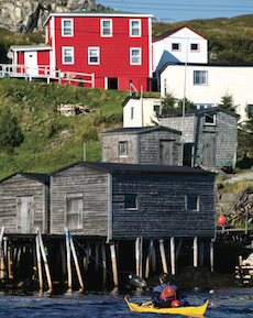
Burgeo is the hub of the Southwest Coast with a highway to the outside world and an increasingly transient population of 1,700. The fish processing plant collapsed with the cod fishery and the town is now more of a bedroom community for Nova Scotia apple pickers and Alberta roughnecks. Streets of quaint saltbox houses radiate haphazardly from the probing fingers of the sea: Short Reach, Long Reach, Mercer Cove and Aaron Arm. The off-lying islands feel removed from the open ocean and make for great sea kayaking for the same reason that Rencontre—the largest of the lot—was chosen as rendezvous site for 17th century French sailors.
Everywhere we spend a night, entire lives have been lived before us. Smallwood for one was a benefactor of the clichéd Newfoundland hospitality—he need not have carried camping gear on his ice walk. Before the advent of deep-sea trawlers and on-board refrigeration, hardscrabble hamlets sprung up as close as possible to the best fishing grounds—sometimes within shouting distance from each other. Some outports date back 500 years to the time of Basque and French fishers and whalers, ranking them among the oldest European settlements in North America.
Up until Newfoundland ceded from England to become a province of Canada in 1949 and Smallwood took reign, outport communities thrived in an isolated, unheralded kind of way. Smallwood began the process of centralization and the majority of outports—like the codfish—started to disappear. By 1975, more than 300 communities and over 28,000 people had been uprooted. Our Sailing Directions guidebook, published in 1995, describes dozens of communities like Petites that have since been “evacuated” due to fishing moratoriums and the lure of greener pastures—not to mention healthy government-issued lump-sum compensation.
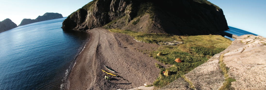
A day’s paddle east of Burgeo, we tuck into a sheltered harbour rimmed by 150-metre talus slopes and forested hillsides and find a spectacular campsite on a gravel spit on the north end of Fox Island. Only two houses remain but the rotting cribbing of old fishing stages and a grassy meadow suggest there were once many more. I follow a trickle of a stream up a bram- bly hillside and discover a shallow-dug well brimming with ice-cold, peaty brown, sugary sweet water. Ryan finds the old cemetery on a dome-shaped promontory, its weather-beaten tombstones overlooking the sea.
The weather settles into a stable trend and the next day we knock off the 18 kilometres of cliff-bound coast between Fox Island and Grey River by lunch. The community of Grey River occupies all of the marginally flat land in a triangle-shaped bight. Otherwise, the 20-ki- lometre-long granite fiord is inhospitable. After some lean years the outport now bustles, though there’s less activity at the wharf than there is at the helicopter landing pad. The fiord echoes with the whirring thump-thump-thump of rotors and reeks of aviation fuel—the sounds and smells of a prospecting boom.
Luckily, the crux of the trip comes on a magical day of lifting fog, skirting clouds and bright sun and we tackle the better part of the near-continuous 300-metre-high cliffs connecting Grey River to Francois in idyllic conditions. The landscape blows the mind—as much Newfoundland as it is a combination of Alaska, Hawaii and Thailand. A talus valley bound by soaring, glacier-worn buttes fans out to the sea at the tiny in- dentation of Seal’s Rest Cove. And at Cape La Hune, craggy, crumbling spires of volcanic rock contrast with neighbouring slabs of granite. We round the promon- tory rubbernecked and walleyed and set up camp at another abandoned outport.
 We spend two days at Cape La Hune not because of miserable weather—by now the Southwest Coast is fully enveloped in a 1,025-millibar high—but because it’s so hard to leave. Hiking up the breadbox-shaped peak behind the campsite oc- cupies an afternoon with scrambling up sloping rocks and crashing through tuckamore thickets of dwarf birch and fir trees. From the top, the Atlantic stretches uninterrupted to Antarctica, save for the inconspicuous dots of the French islands of St. Pierre and Miquelon to the south- east. Facing inland, La Hune Bay cuts a granite corridor through a sweeping expanse of tucka- more and barrens. On the treacherous descent I find an old threadbare rope—proof that the Cape La Hune outporters did more than just fish. Later on, I watch the moon rise over the rockbound coast from within the foundation of the old church, imagining the building itself departing on a barge bound for the horizon.
In some ways, there was method to Smallwood’s madness. Like a used car salesman pitching to the spouse who’s keener on colour than anything else, Smallwood appealed to the outports where, at the time, the provincial balance of power was held. As dubious as his reputation was in St. John’s, Smallwood became a backwoods legend for his Southwest Coast sea ice expedition and popular radio show. He solidified his cause by flying into these same remote communities that had never seen an automobile, let alone an airplane, with promises of money for all should Newfoundland vote to join Canada.
Walking the ice of the Southwest Coast, Smallwood found communities of people who knew nothing of the concept of unionized labour, much less government and current affairs—the same way he was ignorant of their arduous and simple lives by the sea. Maybe Smallwood’s resettlement plans and promises of centralized labour and its associated benefits were innocently skewed attempts at giving thanks for their hospitality. One way or another, when the people of Newfoundland chose to cut ties with Britain and join Canada largely on the strength of the rural vote, it marked a beginning of the end that continues today.
Upon ending our trip in Francois—with 175 residents, two stores and a high school, the most populous and well-endowed outport on the Southwest Coast—the weather takes a turn for the worse. We board the coastal ferry in foggy drizzle and southerly winds, with the wavelets in the bay a gut-churning harbinger of what’s to come on the open coast. The last thing I remember before falling into the throes of nausea is spotting a pink, white and green Republic of Newfoundland flag flying taut alongside a line of sopping wet clothes, less an affront against Smallwood than a fading grasp on a way of life.
Conor Mihell is a freelance writer and kayak guide based in Wawa, Ontario.
 This article first appeared in the Summer 2008 issue of Adventure Kayak Magazine. For more great content, subscribe to Adventure Kayak’s print and digital editions here.


