Those looking to go canoeing and kayaking near Ottawa are in luck—one of the premier paddling destinations in the entire province is merely a one- or two-hour drive away, depending where in the region you decide to explore. This place is known as the Ottawa Valley. Located to the west of Ottawa, “the Valley” stretches along the Ottawa River from Arnprior up to Deep River and extends west to Barry’s Bay.
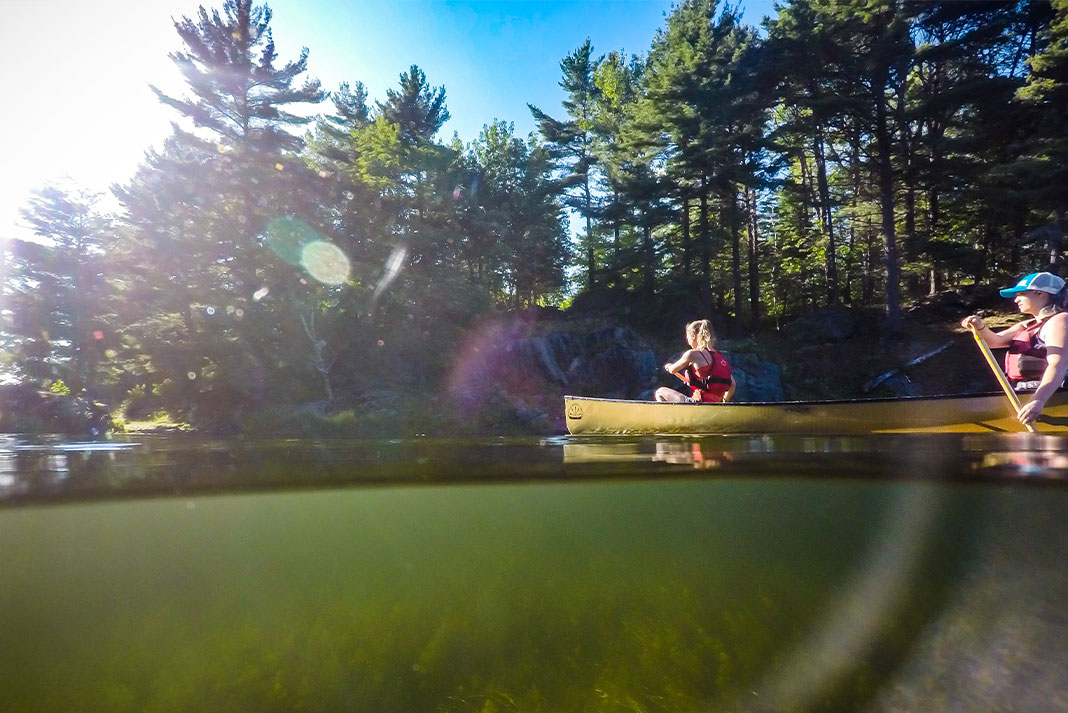
Known as the Whitewater Capital of Canada, the Ottawa Valley is home to some of the fastest, cleanest, warmest and safest rivers in the country—but did you know that the area also boasts more than 900 beautiful lakes? From the pristine, clear lakes of the Algonquin and Madawaska Highlands to the gentle reaches and roaring rapids of the mighty Ottawa River, the Valley offers something for every paddler to explore and enjoy.
[This article is part of the Ultimate Ottawa Valley Adventure Guide. Find all the resources you need to plan an adventure-filled trip to the Ottawa Valley.]
Calabogie Lake, Calabogie
Crystal-clear water and stunning views of some of the highest hills in the Ottawa Valley make Calabogie Lake one of the region’s best lakes for canoeing, kayaking and paddleboarding. The Madawaska River tumbles into the south end of the lake at Barrett Chute and flows out the north side at the village of Calabogie. There are a number of access points for paddlers found around the shores of this large lake, as well as a variety of lodges, resorts and campgrounds for those planning a weekend escape. Kayak, canoe and paddleboard rentals are available at Calabogie Peaks Resort.
An especially rewarding half-day trip for viewing wildlife and waterfowl is to explore the flooded wetland area off Calabogie Lake known as Grassy Bay. This tranquil, marshy bay is separated from the lake by a causeway, originally built as a crossing for the abandoned K&P Railway line. Watch for great blue herons and loons, as well as migrating geese and ducks during spring and fall. Parking is available at the public boat launch behind the tourist information cabin on County Road 511 in Calabogie.
Ottawa River
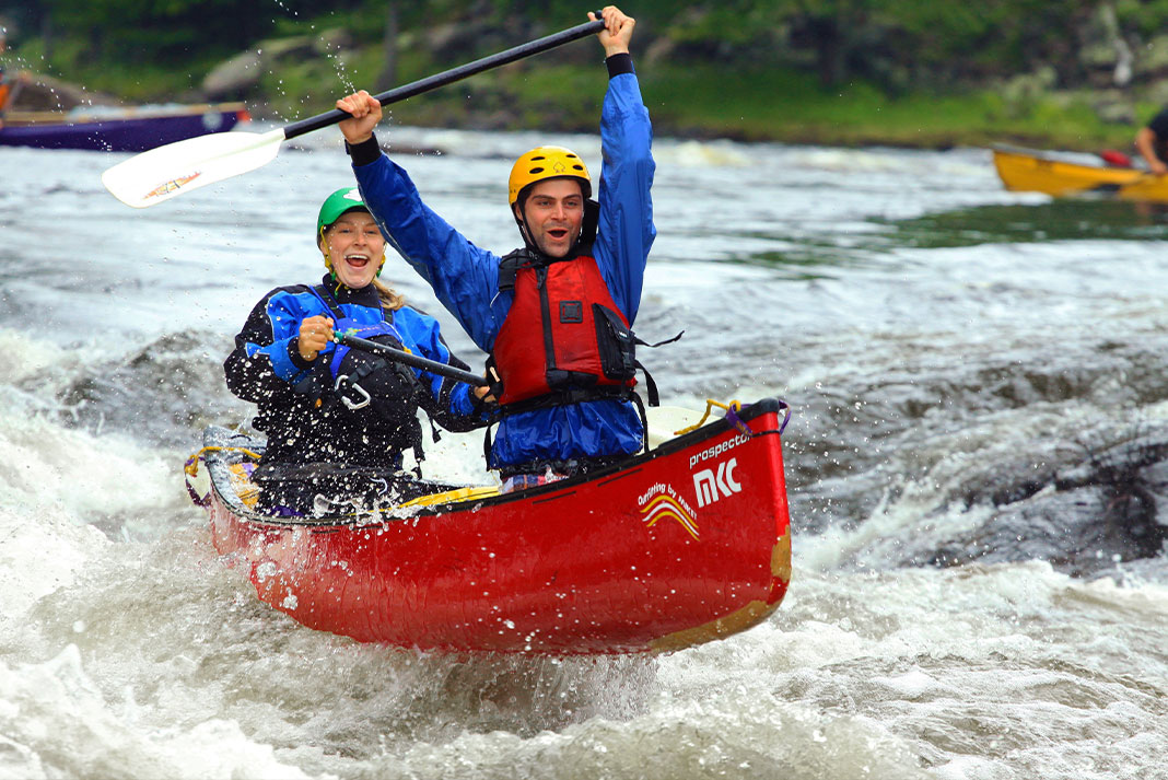
World-renowned as a whitewater playground, the Rocher Fendu (Split Rock) Rapids of the Ottawa River are famous for huge waves, thrilling rapids, pristine scenery and warm water—the perfect combination for sensational Ottawa river rafting.
While the Ottawa River’s more placid reaches are often over-shadowed by its high-adrenaline offerings, another reason this is one of the best rivers near Ottawa is that scenic flatwater paddling options also abound. Highway 17 provides easy access all along the Ontario shoreline. Just about any town, resort or campsite along the river can be the starting point for a paddling day trip. From Mattawa downstream to the Pembroke area, much of the shoreline of the Ottawa is public land available for camping. A few suggested one-day routes include: Deep River to Oiseau Rock or Fraser Landing (on the Quebec side of the river); Petawawa to Fort William, Quebec via scenic island archipelago; and Westmeath to Bellows Bay wetland and sandspit.
Along with rafting, rentals and accommodation, most of the Ottawa River’s acclaimed whitewater resorts also offer guided and self-guided flatwater adventures by sea kayak, canoe or paddleboard. Explore the secret swimming holes, jumping rocks and sandy beaches of the lovely Lower Channel from Wilderness Tours or River Run Campground & RV Park. Or base yourself at OWL Rafting and paddle upriver to Voyageur Bay.
View this post on Instagram
Bark Lake, Barry’s Bay
Located west of Barry’s Bay and upstream from Kamaniskeg Lake, Bark Lake is larger, deeper and wilder than its more popular sister. The Upper Madawaska River enters Bark Lake through a delta of islands in its northwest arm, and exits as the Middle Madawaska near the lake’s south end. The rugged shores and dense forests surrounding Bark Lake are 90 percent crown land, meaning there is very little development and limited access.
Paddlers can access the lower lake at Bark Lake Dam, off Siberia Road at the Madawaska River outlet. Access to the northwest arm is from a public launch off ON-523, 7.5 km south from the village of Madawaska. On the east side of Bark Lake, Sunny Hill Resort occupies an idyllic, grassy hillside with sun-kissed campsites, cottages and RV sites overlooking Bark Lake’s spectacular sunsets. The year-round resort offers canoe and paddleboard rentals from their natural sand beach, as well as a full range of amenities. When the wind is up on the main lake, guests can paddle the sheltered waters of adjacent Littlebark Bay.
Round Lake, Bonnechere Provincial Park
Round Lake owes its clear waters and fine sand to the glacial meltwater of the last ice age, when this area was the delta of a great spillway that drained the Algonquin Highlands. Two provincial parks serve as convenient and scenic departure points for paddling explorations of the lake and the Bonnechere River, which flows through Round Lake.
An easy half-day trip for novices and families begins at Bonnechere Provincial Park near the village of Round Lake Centre and ventures upstream from the lake along the meandering Bonnechere River to Jack’s Chute. Highlights include exploring the river’s oxbows, which are habitat for turtles, fish, ducks and deer. Return to Round Lake for a post-paddle swim, or try your luck fishing for bass, pickerel, pike and lake trout. The park rents canoes and kayaks.
Foy Provincial Park is a hidden gem on the east side of Round Lake, just a few kilometers away from Bonnechere Provincial Park’s better-known beach and campgrounds. Foy is a non-operating park, which means you’ll have to leave your vehicle at the gate on Red Rock Road and walk your boat or board through a stately forest of mature white pine, oak, aspen and birch to the park’s gorgeous, golden-sand beach. An arc of small islands invites mellow paddling journeys beyond the beach.
View this post on Instagram
Golden Lake, Killaloe
As the Bonnechere River makes its way from Algonquin Park to the Ottawa River, it passes through Golden Lake near the charming village of Killaloe. Public launches to access this large lake are available at Station Park in Killaloe (paddle down Brennan’s Creek to reach the lake) and at Bonnechere Lodge on the lake’s south shore. Canoe, kayak and paddleboard rentals are available from Bonnechere Lodge & Cottages and Golden Lake Park Campground at the mouth of the Bonnechere River. Campers and day visitors enjoy exploring upstream along the river, swimming at the campground’s beautiful sand beach and casting for large- and smallmouth bass, pumpkinseed, pickerel and lake trout.
View this post on Instagram
Lake Doré, Eganville
Situated just north of the Bonnechere River and the historic town of Eganville, Lake Doré is so named for the golden color of its refreshing waters (think ginger ale, or pilsner). This is one of the best lakes near Ottawa for easy and convenient day trips, with an excellent public beach and launch located at Melissa Bishop Park. From the park, paddle north along the shore a short distance to the Snake River. The river flows gently to the bird-filled wetlands of Shaws Pond, an old millpond that is now home to the scenic walking trails, old growth forest and interpretive exhibits of the Shaw Woods Outdoor Education Centre. For a longer day trip, take the 270-meter portage to bypass a dam at the end of the pond and continue along the Snake River paddling route as far as your time permits.
Muskrat Lake, Cobden
Long and narrow Muskrat Lake parallels Trans-Canada Highway 17, with the village of Cobden at its south end. The lake is 14 km long and lies in a preglacial valley that occupies an old fault line. Each side of the lake offers distinctly different scenery. Pastoral agricultural lands frame the low-lying west shore of the lake while, to the east, an escarpment of Precambrian rock rises more than 60 meters above the water.
Paddlers seeking a more secluded experience should set their sights on Muskrat Lake’s north end; a public launch with limited parking is located at the intersection of Cornerview and Faught roads. From here, you have a couple fine options: Turn right and paddle up the lake to the mouth of the Snake River, or turn left and paddle out the end of the lake onto the Muskrat River. The first option explores the Snake River Conservation Reserve, while the second penetrates the bird-filled wetlands of Mud Lake. Both of these day trips are wonderful canoe and kayak routes for nature and wildlife sightings, including otters, muskrat, herons, wood ducks and sandhill crane.
Lake Clear, Foymount
Crystal-clear water, a smattering of undeveloped islands and a scenic setting nestled among the hills of the Bonnechere Valley make Lake Clear one of the area’s best lakes for paddlers. A handful of island campsites invite overnight canoeing and kayaking adventures, while the crystalline water means anglers can sight smallmouth bass, lake trout and walleye feeding along rocky shoals.
Two public access points serve as convenient launches for Lake Clear paddlers. At the north end of the lake, Lake Clear Beach features fine sand and a gradual drop-off to deep, refreshing water. Launch here for a peaceful paddle to nearby Hurds Creek, where you may spot snapping turtles or even peregrine falcons performing their aerial acrobatics above the cliffs. At day’s end, tour over to Big Rock and hike to the top to watch the sunset.
For a lovely day tour or camping trip among the islands of the Lake Clear Conservancy, depart from Opeongo Mountain Resort. The islands’ combination of rocky shores and deep water makes for breathtaking swimming and cliff jumping—there’s even an epic rope swing, if you dare. Campsite reservations are required for camping on the islands.
[ Paddling Trip Guide: View all canoe and kayak trips and clinics in the Ottawa Valley ]
Kamaniskeg Lake, Combermere
Kamaniskeg Lake is one of the largest lakes found along the Madawaska River system, and one of its most beautiful. Among anglers, Kamaniskeg is renowned for producing monster northern pike, smallmouth and largemouth bass, as well as walleye, lake trout and rock bass.
Stretching from the town of Barry’s Bay in the north to the village of Combermere in the south, the lake’s many bays are accessible from an array of public beaches and launches scattered around its shores. Because of its size, paddlers should choose an access point based on which part of the lake they would like to explore. If fishing from your canoe or kayak is your aim, put in at Barry’s Bay Public Park or the nearby boat launch and focus on the waters around Mask Island. At the opposite end of the lake, accessible from the Combermere public launch, Blackfish Bay is known for holding lunker pike.
For a scenic day trip with great swimming, picnicking and the chance to paddle over a century-old shipwreck, launch from Hinterland Beach (off Kamaniskeg Lake Road) and follow the lakeshore north through a natural pinch point called The Narrows to reach a pair of undeveloped islands. Look for the wreck of the Mayflower off the north side of the larger island, where you can also head ashore for rock point swimming and cliff jumping. Save this tour for a calm day, as winds on this part of Kamaniskeg can produce dangerous waves.
Madawaska River
Originating at Source Lake in Algonquin Park, the Madawaska River travels for 230 km on its easterly journey to the Ottawa River. Along this winding route, the river links a series of large lakes and sections of still water, alternatively meandering slowly and plunging vigorously through spectacular rapids. While partially tamed by hydroelectric dams, the “Mad” is still a defiant river, mostly undeveloped with some exhilarating whitewater runs for both novice and expert paddlers, making it one of the best places to kayak near Ottawa.
Whitewater paddlers seek out three primary sections of the river. The Upper Madawaska links Algonquin Park with Bark Lake, featuring a 27-km section of challenging Class II–V whitewater between the villages of Whitney and Madawaska. The Middle Madawaska comprises 5 km of Class I–IV rapids between Bark Lake and Kamaniskeg Lake. Finally, the Lower Madawaska is an excellent learning river that offers both a popular Class I–IV day run, and a 40-km downriver camping trip. A fourth option centers around a short stretch of Class II–III whitewater at Palmer Rapids—perfect for park-and-play paddling.
For whitewater paddling instruction, retreats and riverside accommodation, contact world-renowned Madawaska Kanu Centre on the Middle Mad, or the Paddler Co-op, located just below the last set at Palmer Rapids.
[ Paddling Trip Guide: View all canoe and kayak trips and clinics from the Madawaska Kanu Centre and Paddler Co-op ]
White Lake, McNab/Braeside Township
Nestled south of the Madawaska River near the historic hamlet of Burnstown, White Lake boasts clean, clear waters and an intricate labyrinth of inlets, arms, islands and narrows—perfect for exploring by canoe, kayak or paddleboard. While the lake measures 16 km long, it claims nearly 100 km of shoreline, much of it undeveloped. In the fall, the surrounding hardwood forest bursts with stunning autumn colors.
The north end of White Lake offers the most amenities, with a diverse selection of campgrounds, RV parks and cottage rentals for overnight visitors. Paddlers can make use of the public boat launch and picnic facilities at the Waba Cottage Museum & Gardens or nearby White Lake Village Beach. There is also a municipal boat launch and beach at the far south end of the lake, off ON-511. Put in here for serene nature paddling among wildlife-rich wetland coves and a lovely archipelago of forested islands. Pack a lunch to enjoy on the island picnic sites, and see if you can find the locals’ favourite swimming hole on Hardwood Island.
Clayton Lake, Mississippi Mills
Flowing through the farmlands and mixed hardwood forests of Lanark County, the Indian River passes through Clayton Lake near the hamlet of Clayton. Paddlers can park and put in at the public launch in Clayton Taylor Park. Circumnavigating this small lake by canoe, kayak or paddleboard is the best way to view the lake’s extensive wild rice beds and prime turtle, duck and marsh bird habitat. Following the northwest shore brings you to the mouth of the Indian River. Look for picnic sites along the river and on the lake’s small islands. Anglers can try their luck for pike, walleye, bass and perch. For lakeside camping and rustic cottage accommodation, check out these two family-run campgrounds: Thompson’s Black Rock Park and Clayton Lakeside Campground.
Find leisurely and thrilling paddling opportunities in the Ottawa Valley. | Photo courtesy: Destination Ontario


")


Is there anyone who managed to find the swimming hole on Hardwood Island? Please share cymac_92@hotmail.com